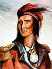
The Shawnee, or Shawano, are a people native to North America. They originally inhabited the areas of Ohio, West Virginia, Kentucky, and Pennsylvania. Tecumseh, a great Shawnee chief, is pictured at the right. See also the Contemporary Kansas Shawnee History, below.
|
|
|
|
Prehistory to 1750s
The prehistoric origins of the Shawnees are quite uncertain. The other Algonquian nations regarded the Shawnee as their southernmost branch, and other Algonquian languages have words similar to "shawano" meaning "south". However, the stem shawan does not mean "south" in Shawnee, but "moderate, warm (of weather)". In one Shawnee tale, Shawaki is the deity of the south. Some scholars have speculated that the Shawnee are descendants of the people of the prehistoric Fort Ancient culture of the Ohio country, although other scholars disagree, and no definitive proof has been established.
Sometime before 1670, a group of Shawnee had migrated to the Savannah River area. The English of Province of Carolina based in Charles Town were first contacted by these Shawnees in 1674, after which a long lasting alliance was forged. The Savannah River Shawnee were known to the Carolina English as "Savannah Indians". Around the same time other Shawnee groups migrated to Florida, Maryland, Pennsylvania, and other regions south and east of the Ohio Country. Historian Alan Gallay speculates that this Shawnee diaspora of the middle to late 17th century was probably driven by the Iroquois Wars that began in the 1640s. The Shawnee became known for their widespread settlements and migrations and their frequent long-distance visits to other Indian groups. Their language became a lingua franca among numerous tribes, which along with their experience helped make them leaders in initiating and sustaining pan-Indian resistance to European and Euro-American expansion.
Prior to 1752, they had a headquarters at Shawnee Springs near Winchester, Virginia, where the father of the later chief Cornstalk had his court. At some point, they had settled in the Ohio country, the area that is now West Virginia, southern Ohio, and northern Kentucky.
The Iroquois later claimed the Ohio Country region by right of conquest, regarding the Shawnees and Delawares who resettled there as dependent tribes. A number of Iroquois also migrated westward at this time, and became known as the Mingo. These three tribes—the Shawnee, the Delaware, and the Mingo—became closely associated in the Ohio country.
Sixty Years' War, 1754–1814
After the Battle of the Monongahela, in 1755, many Shawnees fought with the French during the early years of the French and Indian War until they signed the Treaty of Easton in 1758. When the French were defeated, in 1763, many Shawnees joined Pontiac's Rebellion against the British, which failed a year later.
The Royal Proclamation of 1763, which was issued during Pontiac's Rebellion, drew a boundary line between the British colonies in the east and the Ohio Country, which was west of the Appalachian Mountains. The Treaty of Fort Stanwix in 1768, however, extended that line westwards, giving the British a claim to what is now West Virginia and Kentucky. Shawnees did not agree to this treaty: it was negotiated between British officials and the Iroquois, who claimed sovereignty over the land although Shawnees and other Native Americans hunted there.
After the Stanwix treaty, Anglo-Americans began pouring into the Ohio River Valley. Violent incidents between settlers and Indians escalated into Dunmore's War in 1774. British diplomats managed to isolate the Shawnees during the conflict: the Iroquois and the Delawares stayed neutral, while the Shawnees faced the British colony of Virginia with only a few Mingo allies. Lord Dunmore, royal governor of Virginia, launched a two-prong invasion into the Ohio Country. Shawnee Chief Cornstalk attacked one wing, but was defeated in the only major battle of the war, the Battle of Point Pleasant. In the Treaty of Camp Charlotte, Cornstalk and the Shawnees were compelled to recognize the Ohio River boundary established by the 1768 Stanwix treaty.
Many other Shawnee leaders refused to recognize this boundary, however, and when the American Revolutionary War broke out in 1775, a number of Shawnees advocated joining the war as British allies in an effort to drive the colonists back across the mountains. The Shawnees were divided: Cornstalk led those who wished to remain neutral, while war leaders such as Chief Blackfish and Blue Jacket fought as British allies.
In the Northwest Indian War between the United States and a confederation of Native American tribes, the Shawnee combined with the Miamis into a great fighting force. After the Battle of Fallen Timbers in 1794, most of the Shawnee bands signed the Treaty of Greenville a year later, in which large parts of their homeland were turned over to the United States.
Other Shawnee groups rejected this treaty and joined their brothers and sisters in Missouri and settled near Cape Girardeau. By 1800, only the Chillicothe and Mequachake tribes remained in Ohio while the Hathawekela, Kispokotha, and Piqua had migrated to Missouri.
From 1805, a minority of Shawnees joined the pan-tribal movement of Tecumseh and his brother Tenskwatawa, which led to Tecumseh's War and his death at the Battle of the Thames on October 5, 1813. This was the last attempt (in vain) of the Shawnee nation to defend the Ohio country from American expansion.
After the war
Several hundred Missouri Shawnee left the United States in 1815 together with some Delaware people and settled in Texas, which was at that time controlled by Spain. This tribe became known as the Absentee Shawnee; they were once again expelled in 1839 after Texas had gained its independence three years earlier. These people settled in Oklahoma, close to present-day Shawnee and were joined, in 1845, by Shawnee from Kansas that shared their traditionalist views and beliefs.
In 1817, the Ohio Shawnee signed the Treaty of Fort Meigs, ceding their remaining lands in exchange for three reservations in Wapaughkonetta, Hog Creek (near Ada) and Lewistown (here together with the Seneca).
Missouri joined the Union in 1821 and, after the Treaty of St. Louis in 1825, the 1,400 Missouri Shawnees were forcibly relocated from Cape Girardeau to southeastern Kansas, close to the Neosho River. During 1833, only the Black Bob's band of Shawnee resisted. They settled in northeastern Kansas near Olathe and along the Kansas (Kaw) River in Monticello near Gum Springs.
About 200 of the Ohio Shawnee followed the Prophet Tenskwatawa and joined their Kansas brothers and sisters in 1826, but the main body followed Black Hoof, who fought every effort to give up the Ohio homeland. In 1831, the Lewistown group of Seneca-Shawnee left for the Indian territory (present-day Oklahoma). After the death of Black Hoof, the remaining 400 Ohio Shawnee in Wapaughkonetta and Hog Creek surrendered their land and moved to the Shawnee Reserve in Kansas.
During the American Civil War, the Black Bob's band fled from Kansas and joined the Absentee Shawnee in Oklahoma to escape the war. After the Civil War, the Shawnee in Kansas were once again dispelled and moved to Oklahoma—whereupon the Shawnee part of the former Lewistown group became known as the Eastern Shawnee and the former Missouri Shawnee became known as the Loyal Shawnee (due to their allegiance with the Union during the war). The latter group was regarded as part of the Cherokee nation by the United States because they were also known as the Cherokee Shawnee.
Today, the largest part of the Shawnee nation still resides in Oklahoma.
Groups
Before contact with Europeans, the Shawnee tribe consisted of a loose confederacy of five divisions which shared a common language and culture. These division names have been spelled in a variety of ways, but the phonetic spelling is added after each following the work of C. F. Voegelin:
Chillicothe (Chalahgawtha) [Chalaka, Chalakatha]
Hathawekela (Asswikales, Sweickleys, etc.)[Thawikila]
Kispokotha (Kispoko)[kishpoko, kishpokotha]
Mequachake (Mekoche, Machachee, Maguck, Mackachack, etc.)[Mekoche]
Pekuwe (Piqua, Pekowi, Pickaway, Picks)[Pekowi, Pekowitha]
Membership in a division was inherited from the father. Each division had a primary village where the chief of the division lived; this village was usually named after the division. By tradition, each Shawnee division had certain roles it performed on behalf of the entire tribe, although these customs were fading by the time they were recorded in writing by European-Americans and are now poorly understood.
This arrangement gradually changed due to the scattering of the Shawnee tribe from the 17th century through the 19th century. Today there are three federally recognized tribes and one state recognized tribe in the United States:
Absentee Shawnee, consisting mainly of Hathawekela, Kispokotha, and Pekuwe, living on the Absentee Shawnee Indian Reservation
Eastern Shawnee
Loyal Shawnee, or Cherokee Shawnee, formerly an official part of the Cherokee nation
The United Remnant Band of the Shawnee Nation, or Kispokotha; recognized by the State of Ohio.
There are presently about 14,000 Shawnee, most in Oklahoma, although some are scattered throughout Alabama; at least five bands of Shawnee (the Old Town Band, the Blue Creek Band, the East Of The River Shawnee, the Piqua Sept of Ohio Shawnee and the Shawnee Nation, United Remnant Band) reside in Ohio, while other descendants of non-affiliated Shawnee, some from historical remnant pocket communities, are scattered throughout the old homelands and elsewhere.
The United Remnant Band (URB) consists of approximately 600 people. This group consists of the descendants of Shawnees that evaded the 1830 expulsion from Ohio. The URB is recognized by the State of Ohio, having been given official recognition by the Ohio General Assembly in 1979. This tribe owns land at several sites in Ohio, including the Zane Shawnee Caverns near Zanesfield, Ohio.
Language
The Shawnee language is part of the Algonquian family and is closely related to Mesquakie-Sauk (Sac and Fox) and Kickapoo.
Famous Shawnee individuals
Tecumseh, the outstanding Shawnee leader, and his brother Tenskwatawa attempted to unite the Eastern tribes against the expansion of white settlement; see also Tecumseh's War. This alliance was broken up by the Americans, leading to the Shawnee's expulsion to Oklahoma.
Blue Jacket, also known as Weyapiersenwah, was an important predecessor to Tecumseh, and a leader in the Northwest Indian War. Blue Jacket surrendered to General "Mad" Anthony Wayne at the Battle of Fallen Timbers, and signed the Treaty of Greenville, ceding much of Ohio to the United States.
Cornstalk, Blue Jacket's most prominent predecessor, led the Shawnee in Dunmore's War, and attempted to keep the Shawnee neutral in the American Revolutionary War.
Black Hoof, also known as Catecahassa, was a respected Shawnee chief and one of Tecumseh's adversaries. He thought the Shawnee had to adapt culturally to the ways of the whites in order to prevent decimation of the tribe through warfare.
Glenn T. Morris, professor and activist
Nas'Naga, novelist and poet.
Linda Zarda Cook, United States CEO of Shell Gas & Power, part of Royal Dutch Shell, in London and later in Canada. The first of a very few female leaders in the male dominated oil industries. She has been recognized as one of the world's leading female entrepreneurs.
A Contemporary Kansas History of the Shawnee
by William G. Cutler (1883)
The Missouri Shawanoes were the first Indians removed to the territory set apart for emigrant tribes by the treaties of June, 1825, with the Kanzas and Osages. By treaty made at St. Louis, November 7, 1825, the United States granted "to the Shawanoe tribe of Indians within the State of Missouri, for themselves, and for those of the same nation now residing in Ohio who may hereafter emigrate to the west of the Mississippi, a tract of land equal to fifty miles square, situated west of the State of Missouri, and within the purchase lately made from the Osages."
The tract of fifty miles square thus granted, as afterward surveyed and conveyed to the tribe by deed May 11, 1844, was bounded as follows: "Beginning at a point in the western boundary of the State of Missouri, three miles south of where said boundary crosses the mouth of Kansas River, thence continuing south and coinciding with said boundary for twenty-five miles; thence due west 120 miles; thence due north until said line shall intersect the southern boundary of the Kanzas Reservation; thence due east, coinciding with the southern boundary of said reservation, to the termination thereof; thence due north, coinciding with the eastern boundary of said reservation, to the southern shore of the Kansas River; thence along said southern shore of said river to where a line from the place of beginning, drawn due west, shall intersect the same."
The Shawanoes had their ancient home in the basin of the Cumberland River. Their territory was invaded by the Iroquois about the year 1672, and the vanquished Shawanoes, fleeing to the South, were scattered over various parts of the country--settling in the Carolinas, at the head-waters of the Mobile River, in Florida, and it is related that one tribe had "quite gone down to New Spain." After a short time, several of the tribes re-united and returned to the vicinity of their old hunting-grounds, forming settlements in the valley of the Ohio, where Father Marquette relates that they were "in such numbers that they seem as many as twenty-three villages in one district, and fifteen in another, lying quite near each other."
Several treaties of peace had been made previous to 1786, with the Shawanoes, in common with other tribes, but that of January 31, 1786, was the first concluded with them separately as a nation. By the provisions of this treaty, which was made at the mouth of the Great Miami River, on the northwest bank of the Ohio, the United States allotted to the Shawanoes certain lands on the Miami River, contiguous to the reservations of the Wyandots and Delawares, in consideration of which the Shawanoes, relinquished "all title, or pretense of title, they ever had to the lands east, west and south of the east, west and south lines before described."
The Wyandots protested against this treaty, on the ground that the lands set apart for the Shawanoes had been previously, by treaty, ceded to themselves. The Shawanoes remained, however, on the land, sharing the Wyandot hunting and fishing grounds, and it was in consideration of their forbearance at this time that the latter tribe requested the Shawanoes to cede to them a portion of their reservation in the Indian Territory, when they attempted to negotiate for removal from Sandusky in 1832.
From the time of the treaty of peace which the Shawanoes made with William Penn in 1682 (the first treaty with the whites to which they were a party), the Society of Friends took an intelligent and constant interest in their welfare. Thomas Chalkley, a minister of the London society of the denomination, who visited them as early as 1706, mentions among the peculiarities of the nation its custom of admitting women to its councils. He says: "In the council was a woman who took a part in the deliberations of this council, as well as upon all important occasions.
"On the interpreter being questioned why they permitted a woman to take so responsible a part in their councils, he replied that some women were wiser than some men, and that they had not done anything for years without the council of this ancient, grave woman, who spoke much in this council."
Philanthropic and religious enterprises were necessarily suspended during the long-continued French, English and Indian wars, but after the close of the war of 1812, the Friends again resumed their labors among the Shawanoes, establishing a school, and building flour and saw mills at their village in Ohio. Under the prudent and energetic superintendence of Henry Harvey, the tribe made rapid advance in civilization, and in the year 1831, when their lands were bought by Government, preparatory to the removal of the tribe to the West, the Ohio Shawanoes were prosperous in an eminent degree.
January 4, 1793, Baron De Carondelet, a Spanish nobleman, granted to bands of Shawanoes and Delawares who desired to settle there, a tract of land about twenty miles square, "lying between the River St. Come and Cape Geredeau, and bounded on the east by the Mississippi, and westwardly by White Water."
The Delawares removed from the tract in 1815; the Shawanoes removed from their first location near the cape, and again removed as white settlers encroached on their lands, until, by the treaty of November 7, 1825, they relinquished all title to their Missouri lands, and removed to their reservation in what is now the State of Kansas. In 1831, a treaty was concluded with the Ohio Shawanoes, giving them a certain sum for their improvements in that State, and land contiguous to the Missouri Shawanoes in Indian Territory. A portion of the tribe removed in 1832; the remainder, in the fall of the following year.
The good results of the habits of thrift and industry which these Shawanoes had acquired, aided and encouraged by the influence of the missionaries, who soon settled among them in their new location, were, after a few years, apparent in the comparatively comfortable houses and the well-cultivated fields which multiplied on their reservation. An act was passed in 1853, granting the Ohio Shawanoes $66,000 additional compensation for their improvements in that State--twenty years after their removal. This sum was paid to the Ohio band at their reservation in Kansas.
On May 10, 1854, the tribe ceded to the United States the entire tract set apart for them November 7, 1825, and conveyed to the tribe by deed, May 11, 1844, containing about 1,600,000 acres, and by a provision of the same treaty, the United States retroceded to the tribe "200,000 acres to be selected between the Missouri State line and a line parallel thereto and west of the same thirty miles distant, which parallel line shall be drawn from the Kansas River to the southern boundary line of the country herein ceded."
Three sections of land were to be set apart to the Missionary Society of the Methodist Church South; 320 acres to the Friends' Shawnee Labor School; 160 acres to the American Baptist Missionary Union; five acres to the Shawnee Methodist Church; and two acres to the Shawnee Baptist Church--all to be considered a part of the retroceded 200,000 acres. The residue of the tract was to be divided, each individual receiving 200 acres, to be deeded in fee simple, and whatever remained to be set apart for any other Shawnees who might thereafter unite with the tribe.
The privilege of selecting lands extended to every head of a family who, though not a Shawnee, had legally married into the nation, according to their customs, all persons adopted into the tribe, all minor orphan children of Shawnees, and all incompetent persons, to have selections made adjacent to their friends and relatives.
Other provisions were as follows: "In the settlement known as Black Bob's Settlement, in which he has an improvement, whereon he resides, and in that known as Long Tail's Settlement, in which he has an improvement, whereon he resides, there are a number of Shawnees who desire to hold their lands in common; it is therefore agreed that all Shawnees, including the persons adopted as aforesaid, incompetent persons, and minor children who reside in said settlements, and all who shall, within sixty days after the approval of the surveys hereinafter provided for by the United States, signify their election to join either of said communities and reside with them, shall have a quantity of land assigned and set off to them in a compact body, at each of settlements aforesaid, equal to 200 acres to each indvidual in each of said communities."
Article 4, reads as follows:
"Those of the Shawnees who may elect to live in common, shall hereafter be permitted, if they so desire, to make separate selections within the bounds of the tract, which may have been assigned to them in common, and such selections shall be made in all respects in conformity with the rule herein provided to govern those who shall in the first instance make separate selections."
By Article 6, the grants of land made to missionary societies and churches were subject to the following provisions:
The grant to the Missionary Society of the Methodist Episcopal Church South, to be confirmed to the society, or to such person or persons as might be designated by the society, on the allowance by the society of $10,000, to be applied to the education of the Shawnee youth.
The grants to the societies of the Baptists and Friends to be held by their respective boards so long as the schools connected therewith should be kept in operation; whenever the schools were finally suspended, the lands, with the improvements, to be sold at public sale to the highest bidder--the proceeds to be applied to the use of the Shawnees--minus the value of the improvements, which should be given to the respective boards.
Joseph Parks and Black Hoof, principal chiefs, at the request of the tribe, were allowed to select certain lands--Joseph Parks' being equal to two sections, including his residence and improvements; and Black Hoof's being equal to one section, including residence and improvements. The treaty was signed by Joseph Parks, Black Hoof, George McDougal, Long Tail, George Blue Jacket, Graham Rogers, Black Bob, Henry Blue Jacket--representing the bands that were parties to the treaty of November 7, 1825, and August 8, 1831.
For the land ceded by the Shawanoes, they were to be paid the sum of $829,000, of which $40,000 should be invested for educational purposes, $700,000 paid in seven equal installments, and the remainder within a month of the time of the last annual payment. Henry Harvey, their faithful Quaker friend and teacher, gives the following account of their condition at the time this treaty was made, in his "History of the Shawnee Indians:"
"The Shawnees, in the year 1854, numbered about nine hundred souls, including the white men, who have inter-married into the nation, and are thereby adopted as Indians. This number is perhaps, not more than twenty.
This tribe owns about 1,600,000 acres of land, or about 1,700 acres each. Many of them have good dwelling houses, well provided with useful and respectable furniture, which is kept in good order by the females, and they live in the same manner as the whites do, and live well, too. They have smoke-houses, stables, corn-cribs and other outbuildings. They have a good supply of horses, cattle, hogs, and some sheep. They have many farm wagons, and work oxen--some carriages and buggies, and are generally well supplied with farming implements, and know how to use them. They raise abundance of corn and oats, and some wheat. Their houses are generally very neat; built of hewn logs, with shingled roof, stone chimneys, and the inside work very well finished off, and mostly done by themselves, as there are a number of very good mechanics among the younger class. Their fencing is very good, and taken altogether, their settlements make a very respectable appearance, and would lose no credit by a comparison with those of their white neighbors in the State adjoining them, leaving out, now and then, a farm where slaves do the labor, and thus carry on farming on a large scale.
The Shawnees have a large and commodious meeting-house, where they hold a religious meeting on the first day of each week. They have also a graveyard attached to the meeting-house lot. They hold religious meetings often at their own houses during the week, generally at night. They hold their camp-meetings and their other large meetings in their meeting house, as well as their public councils, and also their temperance meetings, for they, in imitation of their white brethern, and as a means of arresting the worst evil which ever overtook the Indians, organized a society on this subject and have their own lectures, in which they are assisted by some of the missionaries. As regards the settlements of the Shawnees, in their present situation, they are all located on about thirty miles of the east end of their tract. Along the margin of the timbered lands are the Shawnee"s settlements, having timber for buildings, rails and firewood on one side, and on the other side are their farms, and the delightful prairies for grazing, and for hay for their stock in winter.
In passing along the California and Santa Fe roads, which run on the Divide between the streams of the Blue and Osage Rivers and the Kansas River; in casting the eye on either side, a handsome view is presented on both hands of good dwellings, handsome farms bordering on the forest, and fine heads of cattle and horses grazing in the rich prairies as we pass, and beautiful fields of grain sown, planted and cultivated by the Indians themselves. The Shawnees generally sow a large amount of grain, and often spare a large surplus after supplying their own wants."
The Shawanoes eventually established a form of government, the power being vested in the principal chiefs and a council elected by a direct vote of the male adults. This council met semi-monthly, a day constituting a session. At the election of 1855, the members elected to the council were Henry Blue Jacket, Dougherty, Tooley, Simon Hill and Tucker. The Clerk was Matthew King; the Interpreter, Charles Blue Jacket; and the principal chiefs were Joseph Parks and Graham Rogers.
During the war, the Black Bob band abandoned their reservation, which was in the southeastern part of Johnson County, and the title to the lands has been a disputed question for years. The Eastern band of Shawanoes, numbering about ninety, was removed to the Quapaw Reserve, Indian Territory, and the Absentee band, of 688, to the Sac and Fox Reserve.
The Government Agents in charge of the Shawanoe Indians have been the following: Maj. R. W. Cummings, from 1828 to 1849; Luke Lee, from 1849 to 1852; Thomas Mosely, from 1852 to 1854; B. F. Robinson, from 1854 to 1855; R. C. Miller, from 1855 to 1856; Benjamin F. Newsom, from 1856 to 1861; Maj. J. B. Abbott, from 1861 to 1866; H. L. Taylor, from 1866 to 1868; Reuben L. Roberts, from 1868 to 1871.
Shawnee Missionary Establishments
The first mission school among the Shawnees was established by Rev. Thomas Johnson in 1829, in the present town of Shawnee, Johnson County. The mission was under the direction of the Missouri Methodist Conference, and was for several years taught by Rev. and Mrs. Thomas Johnson, assisted by Rev. and Mrs. William Johnson. In 1835, the scholars numbered twenty-seven, supported in part by the mission and in part by their parents. The Church congregation numbered, in the same year, seventy-four Shawnees. In 1839, the school was removed to a location two miles southwest of Westport, Mo., where a grant of 2,240 acres had been secured. Large and commodious buildings of brick were erected, and a manual labor school opened, which was in operation until 1862. The three sections of land granted to the mission by the Shawnees in 1839 were secured to the society by the terms of the treaty of 1854. The school was a successful one, averaging about one hundred pupils.
In regard to the early Methodist missions, Mrs. Lucy B. Armstrong of Wyandot, writes as follows in the Kansas Methodist:
"The history of the missions of the M. E. Church in the Indian Territory before the General Conference of 1844 has been written by abler pens than mine, and I will only state that all the mission schools which had been established in that part of the Indian Territory now included in the State of Kansas were consolidated in one grand establishment--the Indian Manual Labor School, on the Shawnee Reserve, a mile or two west of Westport, Mo. There were about two sections of land inclosed and under cultivation and well stocked with domestic animals, as well as a few buffalo; two large brick buildings for the school teachers rooms, Superintendent's rooms, dining-room, kitchen and rooms for the Missionary to the Shawnees, an excellent flouring-mill, several mechanics' shops, a store for the mission, and quite a village of nice frame dwelling- houses for mechanics and other employes. Bishop Harris, when Missionary Secretary, told the writer that more than $20,000 of the funds of the Missionary Society of the Methodist Episcopal Church had been used in building up the mission previous to the time when the M. E. Church South took possession of it. And, in addition to that, the missionaries had obtained the entire use of the Delaware Indian School Fund of $4,000 per annum for ten years, and the Shawnee School Fund of $1,500 per annum. The produce of the fields was quite a help in supporting the school which did not average as many as 150 pupils per annum, and there was always a long vacation. Thus there were ample means to erect an additional large brick building, which was done in 1846 or 1847, and afterward another section of land was added to it."
The First Baptist Mission was established in 1831, through the efforts and influence of Rev. Isaac McCoy. Dr. Johnston Lykins and wife were appointed by the Baptist Missionary Convention teachers and missionaries to the Shawanoes, and arrived at their post in July, 1831. No appropriation having been made by the Baptist Board of Missions for the erection of buildings, Mr. Lykins purchased a small tract of United States land, immediately on the Missouri State Line, built a small log house at his own expense, and commenced his labors, serving not only as a minister and teacher, but also as physician. In April, 1832, an appropriation was made and the necessary buildings erected. This mission house was the first home of all the early Baptist missionaries.
Rev. and Mrs. Robert Simerwell, Rev. and Mrs. Jotham Meeker and Rev. and Mrs. Moses Merril, all arrived during the fall of 1833, and had temporary quarters at the Baptist Shawnee Mission. In the same year, Dr. Lykins, by authority of Hon. Lewis Cass, Secretary of War, was appointed by the board General Superintendent of Baptist Affairs in the Indian Territory, and the charge of the Shawnee Mission fell into the hands of Mr. Meeker. The church numbered at this time sixteen members, regular meetings being held at the mission house, and occasional ones at the house of the Indians. A school was also in operation. Mr. Meeker brought with him to the Shawnee Mission a small printing press and types, which was put in operation during the winter of 1833-34, and, by the 10th of May, 1834, two books had been printed, according to a system of phonography invented by Mr. Meeker, and several adults, as well as children, had learned to read and write.
In the spring of 1839, Rev. Francis Barker was appointed missionary to the Shawanoes, and removed to the mission. October 23, he was married to Miss Churchill, a missionary at the same post, and under their efficient management, the school, which had been temporarily abandoned, was revived. In 1848, comfortable buildings were erected--mission buildings and a pretty frame church near the old Santa Fe highway. The mission was in successful operation until the latter part of 1855, Dr. Barker being its faithful teacher, minister and physician for over sixteen years.
The Friends' Mission was established in the summer of 1834. A family was sent out by the society to superintend it, a teacher procured and a school organized, which was kept in successful operation many years. In the spring of 1840, Henry Harvey took charge of the mission, and remained two years, the school numbering, when he left, forty children. The mission was supported by the Society of Friends. A large frame house, with barn and outbuildings, and 200 acres of land under cultivation, constituted the mission property.
Mr. Mendenhall was teacher at this mission six years. The Hadleys--Jeremiah and his two sons--and Mr. and Mrs. Thayer, with their two daughters, were also faithful and efficient workers, teachers and Superintendents. The school was discontinued about the time of the opening of the war. The mission received no aid from Government, but was supported by the societies of Friends in Indiana and Ohio.
|
|
|