The Early History of Morton County
by Frank W. Blackmar (1912)
Morton County, in the extreme southwest corner of the state, is bounded on the north by Stanton county; on the east by Stevens; on the south by the State of Oklahoma, and on the west by the State of Colorado. It comprises the territory defined as Kansas county in 1873, except that it extends 3 miles further east. The boundaries were defined in Feb., 1886, by the legislature as follows: "Commencing at the intersection of the section line 3 miles east of the west line of range 39 west with the 6th standard parallel; thence south along said section line to where it intersects the south boundary line of the State of Kansas; thence west along said boundary line to the southwest corner of the State of Kansas; thence north along the west boundary line of the State of Kansas to where it intersects the 6th standard parallel; thence east to the place of beginning."
Morton was constructed out of territory belonging to Seward county, and was organized in 1886. In response to a petition presented to the governor E. F. Henderson was appointed as census taker in April, the returns were made in September and showed a population of 2,360, of whom 780 were householders, the assessed valuation of property was $681,835, of which $504,520 was real estate. Two petitions were sent in for the location of temporary county seat—one in favor of Frisco, to which were attached 1,488 names, and the other for Richfield with 1,473 names.
As these petitions could not be legally signed by any but legal voters, and the two petitions contained 2,231 more names than there were legal voters in the county, the organization of Morton had to be held up pending an investigation to ascertain which had the most eligible names. This took until November, and in the meantime another petition came in for Richfield, which was found to be the choice of the majority.
The proclamation was issued by Gov. John A. Martin on Nov. 17, 1886, and designated Richfield as the temporary county seat. The following officers, recommended by the people, were appointed: County clerk, E. F. Henderson; commissioners, D. D. Sayer, James McClain and Frank Robinson. In December the Kansas Town company, which had founded Frisco, sold that town with its site of 480 acres for $25,000 to the Aurora Town company, which owned Richfield. The county seat election was held on Feb. 3, 1887. Richfield won over Frisco by a majority of 303, and the "People's Ticket" was elected as follows: "County clerk, J. R. Webster; register of deeds, L. B. Weidenhamer; clerk of the district court, George M. Havice; treasurer, E. Evershed; sheriff, J. E. Kelly; superintendent of public instruction, Walter L. Holcomb; surveyor, G. A. Henry; county attorney, J. G. Northcutt; probate judge, D. D. Sayer; coroner, H. C. Finch; commissioners, G. B. Pack, Thomas Cooper and J. W. McClain; representative, John Beatty.
The election was attended by considerable trickery and scheming. At Taloga the opposition to Richfield rented every vacant building in town so that the election board could not find a place to locate the polls. The board went to work, soon erected a building and the polls were opened.
The settlers in Morton county came principally from the older counties of the state. While it was known as Kansas county a village called Sunset had been founded. When the new influx of settlement came, the prospect of Morton county being organized, led to new towns being founded and the old ones were allowed to die.
In 1888 an agricultural exhibit from Morton county, on display in Topeka, attracted considerable attention, especially the Egyptian corn, the stalks of which were used for fuel in the early days. Of the 2,905 claims in the county, nearly two-thirds had been taken by 1886. Many of these were later sold for taxes. The county officials had the foresight to buy up a great many of these, and sold them later at a big profit. This is one reason that Morton county is out of debt and has a fine court-house all paid for.
The "hard times" began early in Morton county. In the four years following the organization the population shrunk from 2,560 to 724. In the next ten years it went as low as 304. In 1906 it had begun to recover, but the population was still very sparse. A series of good years helped the growth, and the population in 1910 was 1,333.
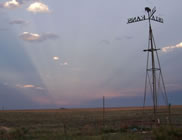
The county is divided into 3 townships, Cimarron, Richfield and Taloga, and there are 10 organized school districts. The general surface is rolling prairie, the soil being a dark yellow color. Bottom lands average a mile in width and comprise 10 per cent. of the area. Native timber is scarce, but a number of artificial plantings have been made. Both forks of the Cimarron river flow northeast through the county. Limestone, sandstone and gypsum exist in several places, and salt marshes are found in abundance.
The farm products are worth about $250,000 per annum. In 1910 the leading crop was broom-corn, which brought $97,744; milo maize brought $61,400; sorghum for forage and grain, $23,940; Kafir corn, $23,585; corn, $9,972. Live stock sold for slaughter, dairy products, poultry and eggs netted $25,000. The total value of all products was $254,061. The assessed valuation of property was $1,763,893.
Law and government
Although the Kansas Constitution was amended in 1986 to allow the sale of alcoholic liquor by the individual drink with the approval of voters, Morton County has remained a prohibition, or "dry", county.
Geography
According to the U.S. Census Bureau, the county has a total area of 1,891 km² (730 mi²). 1,890 km² (730 mi²) of it is land and 0 km² (0 mi²) of it (0.00%) is water.
Demographics
As of the census of 2000, there were 3,496 people, 1,306 households, and 961 families residing in the county. The population density was 2/km² (5/mi²). There were 1,519 housing units at an average density of 1/km² (2/mi²). The racial makeup of the county was 88.39% White, 0.20% Black or African American, 1.14% Native American, 1.06% Asian, 7.52% from other races, and 1.69% from two or more races. 14.10% of the population were Hispanic or Latino of any race.
There were 1,306 households out of which 36.60% had children under the age of 18 living with them, 64.20% were married couples living together, 6.80% had a female householder with no husband present, and 26.40% were non-families. 24.30% of all households were made up of individuals and 9.20% had someone living alone who was 65 years of age or older. The average household size was 2.63 and the average family size was 3.15.
In the county the population was spread out with 29.30% under the age of 18, 8.00% from 18 to 24, 27.20% from 25 to 44, 21.50% from 45 to 64, and 13.90% who were 65 years of age or older. The median age was 36 years. For every 100 females there were 94.40 males. For every 100 females age 18 and over, there were 93.70 males.
The median income for a household in the county was $37,232, and the median income for a family was $43,494. Males had a median income of $31,875 versus $19,474 for females. The per capita income for the county was $17,076. About 8.50% of families and 10.50% of the population were below the poverty line, including 14.00% of those under age 18 and 5.20% of those age 65 or over.
Cities and towns
Incorporated cities
Name and population (2004 estimate):
Elkhart, 2,081 (county seat)
Rolla, 453
Richfield, 45
Unincorporated places
Wilburton
Education
Unified school districts
Rolla USD 217
Elkhart USD 218
|