|
|
|

|
|
Leavenworth County,
Kansas
|
|
|
|
|
|
Leavenworth County is a county located in Northeast Kansas. The official county code for Leavenworth County is LV. The county's population was estimated to be 73,628 in the year 2006, making it the sixth largest in the state. Its county seat and most populous city is Leavenworth. The U.S. Army's Fort Leavenworth is located in Leavenworth county, just north of the city of Leavenworth. |
|
|
|
The Early History of Leavenworth County
by William G. Cutler (1883)
Leavenworth County was one of those originally erected by the First Territorial Legislature of 1855. Its boundaries, as first defined in the Territorial act, Section 27, were as follows:
Beginning at a point on the southern boundary of Atchison County (before defined in the same act) due north of a point four miles west of Dawson's crossing of the Fort Riley road, on Stranger Creek; thence due south to the main channel of Kansas River; thence down said channel to where said channel crosses the channel of the Missouri River; thence up said channel of the Missouri to the southeast corner of Atchison County; thence along the southern boundary to the place of beginning.
The boundaries, as then defined, embraced essentially the present county and the county of Wyandotte, lying south of it. Wyandotte was detached and erected into a separate county, by act of the Territorial Legislature, January 29, 1859. The part of the new county detached from Leavenworth, is described in the act as follows:
Commencing at a point in the middle of the channel of the Missouri River, where the north line of the Delaware Reserve intersects the same; thence on said line west to the line between Ranges 22 and 23; thence south on said Range line to the southern boundary line of Leavenworth County; thence east on said line to the middle of the Missouri River; thence up the main channel to the place of beginning.
The County of Leavenworth was thus diminished to essentially its present proportions, which are defined in the compiled statutes of 1881, thus:
The County of Leavenworth is bounded as follows: Beginning at the southeast corner of Atchison County; thence west with the south boundary of Atchison County, to the corner of Sections 21, 22, 27, and 28, of Township 7 south, of Range 20 east; thence south with the section lines between the third and fourth tiers of sections, to the middle of the main channel of the Kansas River; thence down said Kansas River, in the middle of the main channel thereof, to the intersection of the Range line between Ranges 22 and 23 east; thence north on said line to the old Delaware Reserve line, the same being the dividing line between the original Delaware Reservation and Delaware Trust Lands; thence east, with said reserve line, to the western boundary of the State of Missouri; thence northerly, with said western boundary line of the State of Missouri, to the place of beginning.
It is bounded: North, by Atchison County; east, by the Missouri River; south, by Wyandotte County and Kansas River; and west, by Jefferson County.
The present subdivisions are as follows: Towns - Easton, Kickapoo, Alexandria, High Prairie, Delaware, Tonganoxie, Stranger, Fairmount, Reno, Sherman; City of Leavenworth; and the United States Military Reservation of Fort Leavenworth.
As originally formed, Leavenworth County was a purely river district. By the creation of Wyandotte County, its southeastern portion was cut off, leaving the Missouri River for its northeastern boundary merely. Leavenworth is one of the flourishing northeastern counties of Kansas, and has an area of 455 square miles. There is an abundance of timber and rolling prairie land, and the whole surface of the county is well watered by streams or living springs. Good well water is obtained at a depth of from fifteen to twenty-five feet. Stranger Creek enters the county of way of Easton Township, flows in a generally southerly direction through Alexandria, the southwest corner of High Prairie, through Stranger and Sherman townships, and empties into the Kansas River. Its tributaries, the Little Stranger, Tonganoxie, Nine Mile creeks, drain much of the territory further east and southwest. Kickapoo, High Prairie, Leavenworth and Delaware townships, in the northeastern part of the county, are also drained by multitudes of smaller streams flowing into the Missouri River.
The face of the country is thus divided: Bottom land, 20 per cent; upland, 80 per cent; forest, 10 per cent; prairie, 90 per cent. The general surface is undulating, with bluffs near the Missouri River. The bottom lands average from one to one and a half miles in width, the timber belts being about the same. White oak, walnut, burr oak, cottonwood and hickory are the natural varieties of wood, and in districts not well wooded the cultivation of timber is rapidly progressing.
The surface of the country, away from the river bottoms, which are level alluvial prairie, is undulating, being broken into mounds and detached elevations of considerable altitude along the Missouri River, and declining into a continuous rolling prairie a few miles inland. It is somewhat sparsely wooded. The timber belts extend up and down the Stranger and along the river bottoms of the Kansas and Missouri, and average a mile in width. The principal varieties are white oak, burr oak, walnut, cottonwood, hickory, elm and hackberry.
The soil is, throughout the uplands where no croppings of rock appear, a rich loam of somewhat reddish color, owing to its admixture with the "bluff" or "loess" deposit of the Missouri. The bottoms are the thick black alluvium deposits so common in the Western States as to need no further description. The soil for several feet from the surface is so rich in vegetable matter as to render its fertility well nigh inexhaustible. The whole surface of the county is arable land, capable of producing large and reliable crops of all cereals and other agricultural products common to the latitude or climate. Wheat, corn and flax are the leading staple products.
Blue limestone, of a hard, durable texture is found underlying nearly the whole of the county, it being extensively quarried at the penitentiary, near Leavenworth. Sandstone is also found in the southern part of the county, while traces of hydraulic cement and fire-clay have been discovered in Reno Township, in the southwestern part. But the great geological blessing for which Leavenworth County is truly thankful is her coal, which underlies about seven per cent of her area. It is found at a depth of from fifty to 700 feet, and the mines which have been in operation near Leavenworth City since 1870, are pronounced by experts to be among the most valuable and extensive west of Ohio. This coal contains 56 per cent carbon, while the best bituminous deposits of Pennsylvania contain but 64 per cent. It is pronounced by railways and manufacturers as far superior to all other Western coal for steam making, and is becoming a powerful natural agent in the development of the manufacturing industries of Leavenworth County.
The true Coal Measures which appear in the southeastern area of the State extend persistently north, being found along the towns bordering the Missouri River, in a vein averaging twenty-eight inches in thickness, at a depth of 500 to 700 feet. Less persistent and broken veins have been struck within a depth of 100 feet. Shafts to the lower beds are now being successfully worked at Leavenworth and the State penitentiary, further accounts of which appear elsewhere.
For picturesque beauty the county is unexcelled by any other section of the State. The rough and broken scenery along the banks of the Missouri - the rounded hills, further inland, so regular in form as to seem the work of man instead of the hand-work of nature, robed to the top with the verdure of the green pastures - further still, stretches the great sea of rolling prairie fringed with woodland along the creeks and streams, and along the banks of the Kansas the broad green meadows, shaded with the thick growth of elm and cottonwood - all combined present such varied and lovely types of rural scenery as are rarely found within the restricted area of a single county.
The Oldest County
The county of Leavenworth is, as the abode of white men, the oldest region of the State. The first fort within the limits of Kansas was there established, and the first farm was there tilled by white men. The first postoffice on the upper Missouri was there. The first squatters who came into the Territory after the passage of the Territorial act, drove their stakes in Leavenworth County. The first town organization completed was that of Leavenworth, where the first Kansas paper was printed - The Kansas Herald,, September 15, 1854. The first Territorial Governor, Andrew H. Reeder, first set foot in the Territory in Leavenworth County. The other first Territorial officers: Judges, Surveyors, Secretaries, etc., all made their first official bows to the Delaware Indians, who at that time owned the county, or to their white brethren, who, as citizens of the yet unborn commonwealth, had squatted on the domains of the dusky proprietors, in anxious waiting for whatever might turn up. It is more than likely, although it cannot be proven, that the first stationary steam engine was set to running in Leavenworth, and if so, the first lumber was sawed there. It is certain the first political caucus was held there, as well as the first criminal trial under the Territorial laws. What other first events transpired there will appear in the course of history. Enough have been noted to mark Leavenworth County as one of leading historical importance in the chronicles of the Territory and State.
Fort Leavenworth
See separate page on Fort Leavenworth
Early Settlements
The first white settlers of the county were the farmers who came in to cultivate the lands of the military reservation, and the missionaries who came in with immigrant Indians a few years later.
The actual settlers, who came in immediately after the passage of the Territorial bill of 1854, were the early settlers of Leavenworth County who planted civilization on the ground that had been sacred to the occupancy of Indians, by treaty, from the time of the purchase of the domain in 1803, till then. The Government had marked out a small reservation on which white soldiers and civilians in the employ of the Government might live under its protection, and the Indian missionaries and white farmers and mechanics had, under the protection of the Government, found a safe sojourn within the Territory; yet, up to the time of the passage of the act there was no white man in the county, nor Territory, who had a right, in fee simple, to a rod of ground. So, it seems fit to fix the time of the actual settlement of the county at the date from which titles to land and deeds of the same which are valid to-day can be traced.
The acquisition of a valid title to the lands by early settlers, was fraught with difficulties, and, to a full understanding, it is deemed necessary to diverge from historical narrative sufficiently to render the succeeding account of the early settlement clear.
The Delaware Trust Lands. - by treaty of September 24, 1829, the Delaware tribe of Indians relinquished their lands in Missouri and were assigned a large tract in Kansas, covering all of Leavenworth County, and much more. December 14, 1843, the Delawares sold the Wyandots a tract comprising nearly the area of Wyandotte County. In the spring of 1854 treaties were made by the United States Indian Commissioner whereby, excepting small reserves, nearly the entire Indian title to the Indian lands of Eastern Kansas were put in the way of ultimate extinguishment, and thereby opened to the possession of white men at a more or less remote period, and under conditions and terms varying in accordance with the provisions of the treaties.
Some tribes sold outright, reserving a part for occupation; others ceded to the Government, in trust, to be sold at some future time specified, for their benefit. The Delawares made a treaty May 6, 1854, whereby they ceded to the United States all their lands except a strip along the north bank of the Kansas River, commencing on the western line of the Wyandot lands, and extending up the north bank of the Kansas River forty miles, and being ten miles wide the entire length. This tract, under the name of the Delaware Reserve, remained in the possession of the tribe till May 30, 1860, at which time it was ceded to the Government and sold to the Leavenworth, Pawnee and Western Railway Company, except an assignment, in severalty, of eighty acres to each member of the tribe. This reserve included the southern part of Leavenworth County, ten miles north from the bank of the Kansas River.
The land ceded under the treaty of 1854, embraced the remaining part of Leavenworth County, as well as a part of Atchison County, and extended westward through the adjoining counties. the conditions were, that all the ceded lands, except the long, narrow strip known as "the outlet" (which was ceded unconditionally for the sum of $10,000), should be surveyed in the same manner as the public lands, and, so soon as the whole or any portion of said land was surveyed, that it should be offered at public sale to the highest bidder by the President, in such quantities as he might deem proper, the sales to be conducted in accordance with the laws of the United States in regard to the sale of public lands; such lands as were not sold at public sale, to be subject to private entry for three years at the minimum Government price, and if, at the expiration of that time any yet remained, they might, by act of Congress, be graduated and reduced in price until all were sold. All the money accruing from the sale, after the payment of expenses of survey and sale, were to be paid to, or held in trust by the Government for, the Delawares. These lands were known as the Delaware Trust Lands.
The inhabitants of Platte and the other Missouri border counties, all of whom, from education and interest, favored the establishment of slavery in the Territory, had long known the value of the land on the adjacent domain of the Delawares, and had only waited for the authority of the Government to occupy it. Indeed, the population of Missouri had accumulated to an unnatural degree along its whole western border, where it had been stopped by the Indian reservations, from further occupation. It is not strange that, when the Hon. D. R. Atchison notified his friends in Weston to "go over and take possession of the good land," that they went forthwith without delay, and in total ignorance of the provisions of the treaty.
The men who first settled Leavenworth were of an entirely different stripe from the founders of Atchison, Kickapoo City and Delaware City. They were either moderate Pro-slavery men or pronounced Free-soilers, who intended, to the best of their ability, to forget politics and possess the country for their homes and their firesides. Many of them had been slave-holders, but were disgusted with the persecution which their party were everywhere dealing out to the Free-state party. Some of them, as H. Miles Moore, for example, were so disgusted that they went over the "ranks of the enemy" and incurred the bitter hostility of the Pro-slaveryites.
Many of the men who came from Weston and Platte County, Mo., felt that the repeal of the Missouri compromise was a grievous wrong, but that the very repeal was a compromise which passed the Territory of Kansas over to the Slavery party. The Kansas-Nebraska bill was signed May 30, 1854, and the ultra members of the Pro-slavery party in Weston at once commenced to organize. Many of the moderate members also joined the Platte County Self Defensive Association, under really a misapprehension as to its real objects. But before proceeding further, several statements which should have previously been made, are necessary.
With the belief that the land had been opened for white settlers, and with a full knowledge of its value, the citizens of Platte County fairly swarmed onto the "Delaware Trust Lands." They could do little more than to stake their claims, but under the belief that the lands were, under the existing pre-emption laws of the United States, open for occupation, they took possession. At the close of June, 1854, there was scarcely an acre of what is now Leavenworth County that had not been claimed by some enterprising citizen just over the Missouri border.
A few who really desired to settle in the county, put up cabins and removed their families onto their claims. These, so far as can be ascertained, held their claims through all the changing vicissitudes of the succeeding years, and many of them with their descendants still hold the lands then claimed.
But, by far the largest part of the claims were speculative, made, as the claimants doubtless believed, in accordance with the letter, if not the spirit, of the law, by a class of men living conveniently near in Missouri, but having no intention of establishing a permanent home in Kansas. They, however, from the beginning, by virtue of their putative possessions in the county, assumed all the rights of citizenship, and entered into the Territory and possessed the ballot boxes at all the early elections with the same unanimity and disregard of law that had characterized the establishment of their premature and illegal claims upon the land.
By far the most important occupation, at that time, was on the present site of the city of Leavenworth. A history of the settlement, up to the time of the legal acquirement of proprietorship in the land on which the city now stands, by its founders, gives a clear and full history of the whole dispute pertaining to the settlers and squatters on the Delaware Trust Lands.
The first land occupied or claimed in Kansas by citizens of the United States, after the passage of the Kansas-Nebraska act was within the present limits of Leavenworth City. On June 12, 1854, Gen. George W. Gist, Samuel Farnandis and John C. Gist, staked off and marked the claims where the present city of Leavenworth stands. It had been the opinion of many would-be settlers that the city was destined to be located at Fort Leavenworth. But it soon became evident that the Government had no intention of abandoning it as a military post, and accordingly, the next day after Gen. Gist and his friends had staked their claims, a meeting was called at Weston for the formation of a town association.
The various squatters in Leavenworth and vicinity, who had taken claims near the coming city of Fort Leavenworth, held a meeting at Riveley's store, in Salt Creek Valley, on Saturday, June 10, 1854. This was the first squatter meeting ever held in the Territory, and it was there resolved to relinquish all rights and titles to the future town association; hence, when it was formed on the 13th of June, everything appeared harmonious. The original proprietors were mostly citizens of Missouri, residing at this time, at or near Weston. They were thirty-two in number. Following are the articles of association as originally drawn up and signed by the members:
ARTICLES OF ASSOCIATION
We, the undersigned, being desirous of procuring a claim to a certain tract of land in the Delaware lands, adjoining the military reservation in the Territory of Kansas, with the ultimate view of perfecting a title to the same from the General Government, have caused the same to be regularly and properly laid out and staked off and marked out, with the name of each member, and a registry of the same made with _____ Grover, a person appointed by the squatters of the Territory for that purpose, to receive and make such entries or registry. For the speedy furtherance of this object, it is hereby mutually and sacredly agreed between the members of this association, each pledging himself to the other, that we will protect and defend each in all possible ways against all aggression whatsoever, until a title to the same is fully perfected; and it is further agreed by and between us that we will hold said tract jointly in common, until a final division of the same may be made by a majority of the members. We further pledge ourselves to furnish the sum of two dollars and fifty cents each for the survey and laying out of said tract, and all other sums that may be assessed by a majority of the members for the purposes of protecting and defending the same from all aggression whatsoever. And we also further pledge ourselves and solemnly promise that we will cordially obey all needful rules and regulations that may be hereafter passed by a majority of this society for the government and protection of its members, upon a no less penalty than that of expulsion from said society, together with the loss of all claims, interest or title in and to said tract above referred to, and all protection from said society, or either of its members, shall thereby be withdrawn. It is further agreed that it shall be optional with George B. Panton, one of our members, to retain and keep for his own use and benefit, the quarter section and the improvements now occupied by him, at the price at which the Government may sell the same, in which event he is to lose all interest in this joint stock company. It is further agreed by the members of this society that Major E. A. Ogden shall have full membership and interest in the society, although not signing these articles.
In testimony whereof we have hereunto set our hands, this 13th day of June, A. D. 1854: Geo. W. Gist, D. H. Stephens, W. H. Adams, L. A. Wisely, Samuel Norton, Samuel Farnandis, John C. Gist, Edward Mix, Malcolm Clark, Frans Impey, Frederick Starr, Merritt Johnson, G. H. Keller, Wm. G. Caples, H. Miles Moore, Lorenzo D. Bird, L. W. Caples, Oliver Diefendorf, Amos Rees, Wm. S. Murphy, Joseph Murphy, G. B. Panton, Jos. B. Evans, John Bull, James F. Benner, J. D. Todd, A. Thos. Kyle, Sackfield Maclin, A. E. Ogden, Samuel F. Few.
(The [above] document is in the handwriting and is now in the possession of H. Miles Moore, Esq., of Leavenworth, one of the original proprietors and the first secretary of the association. The compilers of this sketch are under obligations to him for valuable aid, counsel and information pertaining to the early history of Leavenworth. To Mr. Moore the publishers are also indebted for the revision of the entire history of this county. )
Gen. George W. Gist was elected president: H. Miles Moore, secretary; Jos. B. Evans, treasurer; Amos Rees, L. D. Bird and Major E. A. Ogden, trustees. Committee on By-laws: L. D. Bird, O. Diefendorf and H. Miles Moore.
Subsequent to the first meeting, James W. Hardesty and W. S. Yohe were admitted as original members of the association. Including the two last named gentlemen there were thirty-two original proprietors. Mr. Moore classified them as follows: Ministers, three; lawyers, four; doctors, five; printers, two; merchants, four; surveyors, one; army officers, two; army clerks, one; farmers, eight.
The land embraced in the joint company claim comprised 320 acres. It commenced at the south line of the military reservation, and extended south along the west bank of the Missouri River to Three-Mile Creek, and back from the river sufficiently to comprise the area before mentioned. It was surveyed and platted without delay, by Gen. Gist, and divided into 175 shares, containing twelve lots to each share. Five shares each were apportioned to the original proprietors, the remaining fifteen being reserved in the hands of the trustees, "to be disposed of as they may deem fit for the best interests of the town;" or, perhaps, in the expressive phrase which has since become so familiar to Americans, "to be put where they would do the most good."
A drawing of two lots to each share was had, so as to give each share a first and second-class lot on either the Levee, Main or Delaware, or Shawnee streets, below Second street. A large number of shares were sold to other parties, who signed the constitution and became members of the association. Among those who purchased shares were several army officers, then stationed at Fort Leavenworth, some of whom still own property here - Gen. F. E. Hunt, then Captain of the Fourth Artillery, Gen. Magruder, Gen. B. C. Card, then Lieut. Card, Gen. R. C. Drum, then Lieut. Drum, Lieut. Robertson, Dr. Samuel Phillips, Gen. Joseph E. Johnston, and many others.
The name first selected by a majority of the committee - Bird and Diefendorf - was Douglas, in honor of Hon. Stephen A. Douglas, of Illinois. It was reported to the proprietors for adoption, together with a minority report by Mr. Moore recommending Leavenworth. Influenced by the reasons advanced by him in favor of the name he had chosen, the shareholders adopted it. Thus Mr. H. Miles Moore came to be the godfather of the infant town he has lived to see grow to be the foremost city of the State. At that time it was covered with a dense growth of trees and underbrush - all save a narrow strip between what is now Choctaw street and Three-Mile Creek. To-day the site is as thickly covered with warehouses, churches, school-houses, shops, factories, and the homes of a happy and prosperous people, as then with the woods and brambles of twenty-eight years ago.
The naming of the streets after the various resident Kansas tribes of Indians was done in accordance with the suggestion of Major E. A. Ogden, a member of the first Board of Trustees.
So far the new town met no serious obstacle, but Gen. Atchison and his Pro-slavery friends who were striving to build up Pro-slavery towns, were evidently uneasy at the unpolitical attitude which Leavenworth was assuming. In July some slaves escaped from Weston and vicinity, and it is supposed went to Kansas. This fact caused the formation on the 15th, of the Platte County Self-Defensive Association, which organization extended eventually into many Southern States, and became a bitter opponent of the Free-soil doctrine.
It was often made the instrument of inexcusable oppression, as in the case of the arrest of Thomas A. Minard, of Easton, who in the 21st of July went to Weston on business. There was an attempt made to connect him with the running off of the slaves, but the bottom fact and true explanation of his arrest was that he was a pronounced Free-soiler, though no Abolitionist. Other arrests followed, and the Self-Defensive Association became so aggressive as to attempt to dictate to Leavenworth merchants where and of whom they should buy their goods.
But leaving the incidents and personalities of a full narrative of the early growth of the town, to be treated further on, it is deemed proper to follow the historical thread of the town company, through the trials and struggles of its early life, up to the point where a legal and valid title to the land was obtained, thus giving the reader a clearer understanding of the most vexatious, and, perhaps, least understood, land dispute that harassed the early settlers of Kansas, than would be possible if casually brought to notice in chronological order, in connection with contemporaneous events.
The Beginning of Another Trouble
Scarcely had the town company completed their organization, before it was discovered that Atchison's advice to his friends to "go in and occupy the good land," was premature. It was discovered that the provisions of the treaty, unlike those with the Kickapoos, who ceded lands lying adjacent on the north, precluded the settlement of the Delaware lands, held in trust for the tribe, till they should be surveyed and sold, and when sold, they were to be sold to the highest bidder, regardless of any pre-emption rights of settlers or squatters. It was at first stoutly contended that the lands could be held under the pre-emption laws of the United States; but all hope in that direction was extinguished by a long and elaborate document issued by Attorney General Caleb Cushing, which ended in the expression of the following authoritative and positive opinion:
In fine, my opinion is, that the act of Congress gives pre-emption only in such of those lands ceded as are not required first to be offered at public sale; that the Delawares, Iowas, and Weas, under condition of being first offered at public sale, are no more opened to pre-emption by the act of Congress, than was the military reservation at Fort Leavenworth; that those lands can not be taken up by settlers under claim of pre-emption; and that all claims of pre-emptions there will be merely void in law, and will confer no right now or hereafter, on which to demand the issue of a patent from the Commissioner of Public Lands.
Moreover, it will be the duty of the President to maintain, by force, if needs be, the plighted faith of the United States in this behalf.
The Indian Commissioner, G. W. Manypenny, by whom the treaty was made with the Delawares, took substantially the same view of the case, and, from the beginning, exerted both his personal and official influence in opposition to the settling or encroachment of the white settlers on the "Delaware Lands." However exalted, or otherwise, might have been his motives, he certainly managed to win the thorough and lasting hatred of the settlers, and was the most unpopular and generally abused official whose name appears in the newspaper files of the day, in connection with the land troubles.
Technically, the squatters had no rights, and they knew it, but they were there, and, more especially in Leavenworth, where they had "founded a city," they were determined to remain. So they went doggedly to work, clearing up the brush, staking out the town, and selling shares, regardless of the Attorney General's decision, and the ravings of their opponents. Early in September, about a month before the first sale of lots occurred, Rev. C. B. Boynton visited Leavenworth, and describes it as follows:
About thirty miles above the mouth of the Kansas, we came in sight of an entirely new object, unknown to all former experience - a squatter city - Leavenworth City - three and a half miles below Fort Leavenworth, on the west bank of the Missouri.
In spite of the President and Cabinet, and treaties, the city has squatted upon lands of the Delawares, over which General Cushing has declared squatter sovereignty has no jurisdiction. Twelve hundred and more "sovereigns" have already, it is said, set up their thrones on these Delaware lands; and how they are to be despoiled of their kingdoms, is a question which the Government will not easily solve.
A squatter city has little resemblance to any other city; it belongs to a distinct genus of cities. This is a large and important one, the capital, as many hope, of Kansas, and is therefore worthy of description. There was one steam-engine, "naked as when it was born," but at work sawing out its clothes. There were four tents, all on one street, a barrel of water or whisky under a tree, and a pot, on a pole over a fire. Under a tree, a type-sticker had his case before him, and was at work on the first number of the new paper, and within a frame, without a board on side or roof, was the editor's desk and sanctum. When we returned from the Territory to Weston, we saw the "notice," stating that the editor had removed his office from under the elm tree to the corner of Broadway and the Levee. This Broadway was, at that time, much broader than the streets of old Babylon; for, with the exception of the "fort," there was probably not a house on either side, for thirty miles.
Capital, skill, the spirit of speculation, and government patronage, can accomplish many things, but to bring the trade of the Kansas valley up to Leavenworth City, would be a feat scarcely less remarkable than that of inducing the river itself to take that upward direction.
J. Butler Chapman, Esq., who had himself a paper city on hand, known at that time as Whitfield City, located some seventy-five miles up the Kansas River, published a pamphlet History of Kansas and Emigrants' Guide, in which he describes the natural beauty of the country round about Whitfield, and calls attention to the inevitable destiny that points to his town as the future metropolis of Kansas. He speaks quite disparagingly of Leavenworth. He says: "We make Fort Leavenworth a station and meridian, from whence to compute distance, as Leavenworth City, three miles below, can never be a commercial point, or a depot for the Territory, nor can we see how it can be a point conspicuous for any purpose whatever."
Whatever merit pertained to Mr. Chapman, as a historian or business manager, it is certain he had not the gift of prophecy. Leavenworth is, with possibly a single exception, the largest and most "conspicuous" city in the State; Whitfield City, like Troy, is known only in history. It is numbered with a hundred other paper cities of Kansas that had a name and bright hopes in 1855, a name in 1856, and since then neither.
The First Sale of Town Lots occurred Monday, October 9, 1854. The following account of it is copied from the Herald of Friday, October 13:
On Monday last, at 11 o'clock A. M., the sale of lots in this town was commenced. There was a large assemblage of people on the ground, many of whom had come from a distance for the purpose of attending this sale. The survey had been completed, and charts of the town drawn. The streets had been cleared of rubbish, and marked with their names. Those parallel with the river are number as far out as Seventh street; the cross streets are named for Indian tribes, and, commencing on the south, are as follows: Choctaw, Cherokee, Delaware, Shawnee, Seneca, Miami, Osage, Pottawatomie, Ottawa, Kickapoo, Kiowa, Dacotah, Pawnee, and Cheyenne. The streets parallel with the river are 60 feet wide, and the cross streets are 61 feet wide, except Delaware, which is 70 feet. The lots are 24 feet front by 125 feet deep, and there are 32 lots in each block. through the center of each block runs an alley 15 feet wide. Seven lots have been laid off next the river in warehouse lots, the fronts of which are about 150 feet from the water's edge. All the space between Main or First street and the river, except these several blocks, have been donated for a Levee and Esplanade.
The terms of the sale were one-third cash and the balance payable when the title is secured. G. W. McLane, of Weston, and W. S. Palmer, of Platte City, were the auctioneers. On the first day 54 lots were sold, at an average of $140; on the second day 50 lots were sold, at an average of $120, making the average of both days' sale about $130. Only 4 lots were sold out of the 32 in each block. The sales were distributed equally over the entire site. The purchases were generally made for immediate improvement, but a small number having been sold to shareholders. Every lot that was offered was sold, and many others could have been disposed of, if time had permitted. The highest price paid for any one was $390, the lowest $50. It must be recollected that no lot exceeded 24 feet front.
From the Hon. H. Miles Moore's account of the sale, published in the Leavenworth Daily Commercial, June 14, 1873, the following additional facts concerning it are gleaned:
Mr. Moore now has the original list of purchasers, and the map used at the sale, in his possession. The highest price paid on the first day's sale was $350. It was purchased by Capt. James A. Grant, being lot 3, block 3, where afterward was the wholesale grocery store of Messrs. C. R. Morehead & Co. The lowest price realized on the first day was $50 each for lots 20 and 21, block 14, on the north side of Osage street, next to the alley, between Main and Second streets. The purchaser was Charles Mundee. On the second day, C. A. Williams paid the highest price of the day - $200 each - for lots 15 and 16, block 25. The lowest lots were bid off to C. Mundee, lots 13 and 14, block 31, at $50 each; to Clint. Cockrill, lots 19 and 20, block 31, $50; and to Peter Hanreons, lots 19 and 20, block 32, at $51 each. The aggregate of the two days' sales was $12,609.
Mr. Moore proceeds, in the article from which the above facts are drawn, to pay his respects to Gov. Reeder, who evidently did not stand high in his favor, in the following terms:
Gov. Reeder was present at the sale, and bought, or caused to be bought for him. The morning of the second day, before the sale, I went up with the trustees of the town company to Fort Leavenworth, where Gov. Reeder was stopping, and they directed me to transfer, on the town books, to him, five shares of the town, of the number of shares which were held by the trustees for the benefit of the town company calling for twelve lots each share (60 lots), for the sum of $1,000, worth at least $4,000 then, now worth from $75,000 to $100,000, to be paid for soon. I may add, he also agreed, sub rosa, to put the capital of the Territory at Leavenworth, which latter part of the contract he afterward, when he got the shares all safe and his lots drawn, forgot to fulfill, but started another little capital town speculation, as the history of Kansas will now show, at Pawnee, near Fort Riley. Reeder was the first of the immaculate Governors with which Kansas was so bountifully supplied in her Territorial tutelage. He always had an eye to the main chance. I will pay him particular attention in the future, as he was a gem of the first water. I do not think our books show that he ever paid the $1,000. If he did, he forgot the little capital matter. The boys often laughed about the trick - that Reeder had Yankeed the trustees out of those town shares.
More than two weeks previous to this time, the first sale of lots had occurred at Atchison, which was, from the first, an acknowledged political and commercial rival of Leavenworth. That energetic and wide-awake man, "Uncle George" Keller, had just completed his contract of clearing the Leavenworth town site of its thick growth of timber and underbrush. In this work he employed eighty men, from the middle of June until the middle of September. The Kansas Herald was issuing from its own building, and the Leavenworth Hotel had just been opened two days previous to the sale of lots, by Messrs. Keller & Kyle. Leavenworth was growing rapidly, and Atchison, Kickapoo, and the like Pro-slavery towns, looked on with a jealous eye.
Before recording further the history of the town association, it is necessary to state a sad fact, viz.: that Gen. Gist, its President, and a man of marked ability and unassuming Christianity, died at Weston, on the 21st of November. He was in his sixtieth year, a Mason, high in the order, and a man placed high in public estimation. Gen. Gist, however, was never a resident of Kansas. As previously stated, it was he who surveyed and platted the town site - the original 320 acres. It is called to this day, "The Gist Survey."
It was filed in the Surveyor General's office, at Fort Leavenworth, on December 20, 1854. The members of the association, through their trustees, Major E. A. Ogden, William S. Yohe, and O. Diefendorf, donated to the public all streets laid down on the plat, except Water street and Esplanade. That ground was donated down to the water's edge, "but all privileges, easements and franchises attaching to said land, including ferry right, with the full and entire fee simple to Water street and Esplanade," were reserved to the proprietors.
While the town had thus been passing through the first stages of its development, the Delawares began to view with a jealous and, perhaps, somewhat speculative eye, the occupation of their lands in violation of the terms of the treaty. Their discontent was no doubt intensified by interested whites who, from personal designs, or jealousy of the Leavenworth company, desired to cripple and impede the growth of the new town, or destroy it altogether. It was generally believed by the squatters that Commissioner Manypenny, in his extreme desire to vindicate the merits of the treaty he had made, took extra-official pains to enlighten the Indians as to the encroachments, to render them opposed to any modification of the treaty whereby the lands could be pre-empted, and to otherwise get them into an irascible frame of mind that boded anything but peace and quietude to the squatters. Whatever the influences may have been, the result was a very earnest remonstrance and petition for relief, sent to the Government, signed by the most influential members of the tribe, including many of those whose names were appended to the treaty of 1854. In response, military orders were sent the commandant at Fort Leavenworth to drive off all trespassers on the Delaware Lands. The story of the trouble was told by H. Miles Moore, Esq., in one of a series of historical sketches which appeared in the Leavenworth Daily Commercial - 1873, as follows:
A very strong prejudice existed at Weston against our town among the more violent Pro-slavery men, and also a jealousy of Atchison and Kickapoo, who were our rivals; they being situated on the Kickapoo lands, which were subject to private entry, while Leavenworth was located on the Delaware Trust Lands, which were not subject to the same provisions, but by the terms of the treaty were to be sold to the highest bidder for the sole benefit of the Indians. Some of these Atchison and Weston friends had taken the trouble to inform the Indians that we were all thieves and rascals, and that we had squatted on their lands without any authority, and would soon have their lands all gobbled up, etc., etc. This so excited the Indians that they commenced making complaints to the Indian Department at Washington through their agent.
In the mean time Major Ogden, quartermaster; Major Maclin, paymaster; Col. Hunt, now (1873), paymaster, then captain of artillery; Dr. Samuel Phillips, surgeon, and a number of other officers of Fort Leavenworth, had become interested in the town by the purchase of shares of the town company. An order came from Washington to the military at the fort to drive us off; thus we were placed in an unfortunate predicament between two fires. We got the order delayed until we could make a showing. A committee from the town company was sent down to talk with the Delaware chiefs and get them to understand our position. After they became fully satisfied that the town company as well as the settlers on their lands, which comprised, at that time, by far the largest portion of the then county of Leavenworth open to settlement, were disposed to respect their rights and would pay the price fixed by the Government, or for which it might sell at public auction, they became reconciled.
An attempt was afterwards made, however, as I may have occasion to show, by Indian Commissioner Manypenny, by maligning the character of certain officers at Fort Leavenworth, and, as was charged, attempting to blackmail the town company to bring the settlers on the Delaware Trust Lands and town company into trouble with the Indians, and also the Government at Washington. At the time first above referred to a petition and statement of our situation and grievances was gotten up with great care, and Judge L. D. Bird was dispatched to Washington to lay the same before the President and Departments. Suffice it to say that at this time we were successful, and were not removed.
It is unnecessary, in this connection, to follow, step by step, the company through all its stages of hope and fear, till its title to the town site was assured by actual purchase. The period of uncertainty, to them, in common with all the squatters on the trust lands, lasted nearly two years, during which time the only laws which protected settlers in the occupation of their claims, were those of their own making, subject to the decision of judges of their own choosing, and enforced by officers appointed by themselves. They were co-operative mutual protective associations, outside any legal authority, whereby rude justice was administered, and protection assured.
The people lived under organized Lynch law, which, under the circumstances, was the only law applicable to their surroundings. During this period occurred innumerable quarrels as to claims and titles to claims. Many of them were settled by judges in the squatters' courts, while other contestants fought it out single-handed, sometimes to the bloody issue of death. Much of the violence, many of the outrages, and not a few of the murders, with which the so-called histories of early Kansas abound, had no political significance whatever. The individual contests of those times were oftener for the possession of a squatter's claim than for the love of liberty, or in the defense of the peculiar institution.
Relief came slowly, but it came at last, through the Government sale of the lands, whereby the cloud of uncertainty was dispelled, and, for the first time in the history of Leavenworth, a citizen was enabled to attain a valid and certain tenure to the land he had occupied and improved.
Sale of the Delaware Trust Lands
see Separate Page
Political Organization
Hon. S. D. Lecompte, Chief Justice of the Territory of Kansas, arrived in Leavenworth, January 1, 1855. On the 19th of March he held a preliminary session of the U. S. District Court, Leavenworth County being included in the district embracing Northern Kansas. Beyond a partial organization of the Court, little business was transacted, and adjournment was taken to the third Monday in April, fixed as the time for the regular term. This session was held in a little frame house on the south side of Delaware street, near Third.
When the Court regularly assembled, pursuant to adjournment. W. G. Mathias appeared as clerk and I. B. Donaldson as U. S. Marshall. Previous to the formation of the court by Chief Justice Lecompte, the citizens of Leavenworth County were obliged to settle their disputes by an appeal to "squatter sovereign" organizations and a few justices of the peace, possessing limited civil and criminal jurisdiction, who had been appointed by Gov. Reeder during the previous winter.
Leavenworth County has thus obtained a partial political and judicial organization by April, 1855. The act organizing the county was passed at the first session the Territorial Legislature which convened July 22, 1855, at the Shawnee Manual Labor School. Its boundaries were defined as follows: "Beginning at a point on the southern boundary of Atchison County, due north of a point four miles west of Dawson's crossing of the Fort Riley road in Stranger Creek; thence due south to the main channel of the Kansas River: thence down said channel to where it crosses the channel of the Missouri River; thence along the southern boundary of Atchison County to the place of beginning."
Says Hon. H. Miles Moore in his fine history of Leavenworth County - a man, by the way, as thoroughly posted not only in the history of his own county but of the State, as any one in Kansas. "As will be observed by reference to the map of the State of Kansas, the boundaries of the county have been considerably changed by acts of the Legislature, since its first incorporation. By act of the Territorial Legislature, approved February 28, 1859. Wyandotte County was cut out of the southeast corner of the county and included what was originally embraced in the Wyandot Indian Reserve. The original county of Leavenworth embraced all of the Delaware trust lands that were ceded to the United States by the treaty of 1854; also the Delaware Indian Reserve and the diminished Reserve, the Muncie lands, a small part of the Wyandot lands. A portion of the Delaware Reserve was ceded to the United States for the benefit of the L., P. & W. R. R., afterwards changed to the U. P. R. R. and then to the K. P. The townships of Tonganoxie (April 1, 1867) and of Stranger (February 28, 1859) were added to the townships of the county out of that tract of land. The Delaware Diminished Reserve was ceded to the M. R. R. R. by treaty in 1865, and the townships of Reno, Sherman and Fairmount were created as hereinafter stated. The Muncie lands consisted of seven sections of land on the Missouri River., now in Delaware Township. They belonged to the Muncie or Christian Indians-proteges of the Delaware Indians-and were ceded to the United States by them about the time of the Delaware treaty."
When the first Board of Commissioners met, September 7, 1855, it will be remembered that Governor Reeder had been removed by the Territorial Legislature. Consequently the appointments of John A. Halderman as Probate Judge and President, ex-officio of the Board; Joseph M. Hall, member thereof, Leavenworth, and Matthew R. Walker, of Wyandotte, third member of the Board. These appointments are all signed by Daniel Woodson, Acting Governor, and issue from the Shawnee Manual Labor School, which the Pro-slavery Legislature had decided upon as the temporary seat of the Territorial Government.
As was the invariable rule, these first county officials all swore, when they took the oath of office, that they would support the Nebraska-Kansas Act and the Fugitive Slave Law. The commissions of Judge Halderman and Mr. Hall bear date of August 27, 1855. Mr. Walker, of Wyandotte, was not honored by the Governor until two days later. As stated, the first meeting of the Board was held September 7, 1855; place of gathering, the warehouse of Lewis N. Rees, corner of Delaware and Front streets. James M. Lyle was appointed clerk of the Board and ex-officio recorder and clerk of the Probate Court. At the same meeting the county was divided into Kickapoo, Leavenworth, Delaware, Wyandotte and Alexandria townships, and the temporary seat of justice was fixed the next month at Leavenworth. Subsequently the following county officers were appointed: M. P. Rively, County Treasurer; Bennett Burnham, County Surveyor; James B. Blake, Coroner; Green D. Todd, Sheriff; L. T. Moore, Assessor.
The constables and justices of the peace for the several townships were appointed, so that the county was permanently organized as a body politic. In one particular, however, she was lacking - no decision had been reached upon the permanent location of the county seat. In September the Board of Commissioners appointed A. Dawson, Martin Hefferlin and Samuel H. Burgess as judges of the election to be held on the second Monday of October for the purpose of deciding the matter. Eight miles above Fort Leavenworth was Kickapoo City, a pet of Gen. Atchison and the Pro-slavery party, a thriving village containing saw-mills, groceries, saloons, a newspaper - the Kansas Pioneer - and all the other paraphernalia of civilization and ambition.
Both in a political and a business sense she was a hardy rival - one hard to beat. Six miles below, also on the river was Delaware City, a flourishing and plucky little town, and possessing, like Kickapoo City, indefinite powers of expansion. Election day, Otober (sic) 8, 1855, witnessed a hot triangular fight. Two steam ferries, crowded with voters from Weston and other localities in Missouri under the Pro-slavery thumb, plied between the eastern shore and Kickapoo City and Delaware City. Platte County, Mo., Gen. Atchison's home, turned out some thousand noble voters on that day.
Kickapoo triumphed. She cast 892 votes, to Delaware's 860, Leavenworth's 753, and Center's (an insignificant interior town) 60. The band from Weston pealed forth joy from brassy throats. Cannons roared. Grand ball, and an immense turnout in the evening. But Delaware City had another card to play. She made a charge before which the glory of Kickapoo City went down in darkness. When Delaware City heard the result of the election she suddenly remembered that some of her "citizens" had been debarred from the privilege of voting. Rather than to have injustice done, her polls were thrown open a second day, and the result was, Delaware, 928; Kickapoo, 878; Leavenworth City, 726; Centerville, 66; Uniontown, 2; The Center, 18; Pork Landing, 1.
Then ensued a "legal contest," in which the material features of the Louisiana imbroglio were foreshadowed. On October 16 the corporation of Leavenworth appeared before the Board, through her attorneys, Amos Rees, D. J. Johnson, A. Macauley, et al., and protested against the reception of the Kickapoo and Delaware poll books. When the returns had been canvassed and the result declared, as given above, Judges Hall and Walker proclaimed Delaware City the county seat - Judge Halderman refusing to give any certificate of election or to take any action in the matter.
This occurred at a meeting held November 6. Four days later the formal petition of M. L. Trueswell, H. Miles Moore, et al., against the reception of the Kickapoo and Delaware returns, was ruled out by the Board - Judge Halderman dissenting. The other two members decided that "the Board had no authority to go behind the returns." Amos Rees, in behalf of the city, filed a written notice to the Board of her intention to apply to Judge Lecompte for a writ of injunction against the location of the county seat at either Delaware or Kickapoo.
Gen. B. F. Stringfellow, attorney for Kickapoo, moved that the Delaware returns be thrown out on the ground that voting was continued on Tuesday, October 9. Messrs. Wilson, Almond and Hollingworth objected, on the part of Delaware. Judge Hall sustained Gen. Stringfellow. Mr. Walker decided that Delaware could vote two days if she wanted to. Judge Halderman was quite non-committal. The motion was consequently lost, and it is useless to inform anyone of moderate penetration, the judges did not grant the writ of injunction applied for by Leavenworth. Judges Hall and Walker had declared Delaware City the county seat. In January, 1856, Judge Lecompte decided for Delaware.
It does not seem "out of order" (although it breaks somewhat into the straight line of narrative regarding the location of the county seat) to notice, in brief, the condition of the county finances. By the latter part of 1856, in July, the rate of the county and territorial tax was established. After this came the August term of the United States Court, and the civil commotions - the John Brown war, etc. As Sheriff Todd, who had been vainly endeavoring to collect the county taxes, remarks in a published report to the Commissioners: " Then came the civil commotions, originating out of the rebellion of the Abolition fanatics of the Territory against the laws. The history and circumstances of this period which lasted for nearly two months are fully known and understood by your honorable body. You are fully aware of the almost entire suspension of business during said time. Nearly every public officer of the county was absent, and engaged in upholding the laws of the Territory. Among them was the undersigned," etc., etc.
He knew the Board could not, and would not, censure him for having collected so small an amount of taxes. Furthermore, the sale of the Delaware Trust Lands was soon to take place, and the people were treasuring up their money in order to purchase their homes. The Sheriff reported an almost entire failure to collect the revenue of Leavenworth County, viz: Delinquent taxes, $3,765.07; collections, $690.93. This was in November, 1856. It was a bad state of fiscal affairs, and, Sheriff Todd's resignation was accepted.
A county building 30 x 20 feet (two rooms) having been completed by G. B. Redman, in Delaware City, the county seat was removed there February 20, 1857. In March, L. F. Hollingsworth, one of the most prominent citizens of the new county seat was ordered to build a new jail eighteen feet square, two stories, at a cost not to exceed $600. Delaware's triumph, however, was of short duration, for the Legislature of this year passed an act providing for another election to decide upon the location of the county seat, upon the first Monday of October, 1857.
Kickapoo city accomplished another remarkable feat in the voting line, the Board of Commissioners, upon October 23, announcing the returns to be - Kickapoo city, 1,004; Leavenworth city, 968; Center, 21; Wyandotte, 1.
Whereupon the following proclamation issued forth, it being a verbatim copy:
"At a regular meeting of the tribunal transacting county business began and held at Leavenworth city on Monday, the nineteenth day of October A. D. 1857, the said tribunal proceeded according to the requirements of the statute passed by the legislative assembly of Kansas Territory and approved February 20, 1857, to cast up the votes and proclaim the result to be as above.
"The said tribunal, therefore, does proclaim the said city of Kickapoo to be the permanent seat of 'justis' for Leavenworth County.
" And the said tribunal doth also order that the Sheriff of Leavenworth County do cause this procklamation (sic) to be printed and posted up at least twenty different public places throughout the county, and alsothat (sic) he have the said procklamation (sic) printed in all the papers in the said county of Leavenworth.
(Signed) George W. Purkins, Pres.; William Franklin, Com. (Attest) Henry B. C. Harris, Clerk.
"Ordered by the Board that the county records be removed to the seat of 'justic' as soon as 'practicable.'"
Leavenworth City petitioned that the Kickapoo returns be thrown out, on the ground that voting was not confined to the county; that the predicted returns were not filed in the office of the County Clerk within two days after the election; and that neither the judges not the clerks of the election were sworn according to the law - the latter not at all.
Joseph W. Hall, commissioner from Kickapoo, had died during the preceding June, or it may have been that Leavenworth City would again have been slighted. But her claims were no longer overlooked, and it was finally decided that she had received the majority of the legal votes cast, and was entitled to the county seat. That decision has never been reversed.
County Buildings
In May, the county accepted the land donated by Jeremiah Clark for a court-house square, consisting of the east half of Block 13, being 300 feet on Third street and 180 feet on Central avenue and Walnut street. The other half was purchased for $13,000. John P. Haskell was appointed architect of the county buildings, $35,000 bonds were voted in June, and it certainly looked as if the county was going to obtain a creditable "seat of justis" right away. But, notwithstanding this apparent alacrity, the courts and county offices were located tor many years in the City Hall, over the Market House, corner of Fifth and Shawnee streets, in the same building now occupied by the Fire Department.
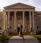
It was not until February, 1873, that the present imposing and convenient Court House was completed. It is built of red brick, with stone trimmings, is two stories in height, with basement, and elegant mansard roof. Its lofty tower and fine clock add to the attractions of as elegant a court-house building as can be found in the West. The building proper cost $120,415.75 Add to this the cost of clock, steam apparatus, fixtures and furniture, the value of the site, etc., and $175,000 would not be an overestimate of the total value of the property. Its situation commands one of the grandest views of the beautiful city of Leavenworth.
In May, 1860, it was first proposed by the county to establish a poor-house. The poor-farm, consisting of 200 acres of land, and a pest-house and poor-house, is situated about four miles southwest of Leavenworth, in High Prairie Township. The average number of inmates is about thirty, and the entire property is valued at $12,000. The county jail, a two-story brick structure costing $10,000, was built in 1872.
County Schools
in 1855, the Territory of Kansas adopted the school law of the State of Missouri, by which each district was to be controlled by and inspector and three trustees. Previous to 1858, however, no districts in this county were formed. A few school districts were then organized. The first County Superintendent was George E. Budington, elected December 14, 1858. His successor was James Taylor, appointed March 4, 1859. In 1861 the State system of public instruction was adopted. Following is a list of superintendents who succeeded Mr. Taylor: Isaac T. Goodnow, elected November 7, 1862; H. H. Bloss, November 8, 1864; B. L. Baldridge, November 6, 1866; H. D. McCarty, November 3, 1868, J. P. Bauserman, November 8, 1870, and November 5, 1878; R. B. Soper, November 2, 1880; Lyman Morgan, November 6, 1882.
The schools of the county are in charge of Lyman Morgan, superintendent of public instruction, and have been brought to a commendable state of perfection. There are seventy-eight districts in Leavenworth County, eighty-four schools and as many teachers. The estimated value of the school buildings is $228,000. They are mostly constructed of wood, but there are some good brick and stone buildings. The furniture and apparatus of the different schools are valued at $41,320. This makes the total valuation in the neighborhood of $270,000. The average monthly wages paid male teachers is $46 and female $40. The average daily attendance at the district schools, outside the city it will be understood, is 5,000. The receipts for the year 1881-82 were $58,000, and the expenditures $56,700, which leaves a balance of $1,300 in the treasury.
Present county officers: Robert Crozier, judge of the district court; John Rohe, clerk of the district court; L. Hanson, judge of the probate court; O. S. Hiatt, county auditor; J. W. Priest, sheriff; Enos Hook, county treasurer; J. W. Niehaus, county clerk; C. W. Curtan, register of deeds; J. C. Lynch, coroner; Thos. P. Penlon, attorney; D. N. Barnes, engineer; Lyman Morgan, superintendent of public instruction; S. F. Rhea, surveyor.
Wealth and Population
The principal crops raised in Leavenworth County are corn, winter wheat and oats. In 1872, the acreage of corn was 43,000. This had increased to over 50,000 acres in 1882. Stranger, Tonganoxie, Fairmount, Sherman, Easton and Alexandria townships making an especial good showing. The increase during ten years in the acreage of winter wheat has been proportionately much greater, from 4,245 in 1872 to over 29,000 acres in 1882. Kickapoo, Fairmount, Reno and Easton are now (July 1882) the banner townships. The acreage of oats has increased within the decade from 8,714 to over 11,000. The whole number of acres in farms is 228,524, and the value of property $12,299,385.
That the county has no fears of famine is inferred from the fact that 146,022 bushels of old corn were on hand March 1, 1882. During that spring the busy farmers also planted 50,424 of their acres to corn and 11,385 to oats. Leavenworth County is also favored as a dairy and live stock county. During the past year over 280,000 pounds of butter were produced. There are 8,500 horses in the county, 7,700 cows, over 12,000 other cattle, 4,000 sheep and 20,000 swine. As to orchards, she has, in round figures, 170,000 apple trees in bearing, 70,000 peach and 21,000 cherry.
From the figures of the assessors it is learned that the total value of all taxable property in Leavenworth County is $7,227,796.69 against $6,519,279.12 for 1881. The number of acres of taxable property is 283,093; of town lots, 13,069. The average price paid for improved land throughout the county is $25 per acre; unimproved from $5 to $10. The aggregate value of railroad property is $707,038.69.
From 1860 to 1870, the population of Leavenworth County increased from 12,606 to 32,444. In 1875 the population had decreased to 27,698. Since then the increase had been gradual but healthy. According to the last returns (made in the summer of 1882) the figures by townships and cities are: Alexandria, 1,017; Delaware, 1,597; Easton, 1,145; Fairmount, 928; High Prairie, 1,129; Kickapoo, 1,528; Leavenworth City, 18,766; Reno, 874; Sherman, 1,173; Stranger, 1,151; Tonganoxie, 1,208; Tonganoxie City, 321; Lansing 231. Total for 1882, 31,068
Weather Record
The following meteorological record for the past thirty years, furnished by William T. Marvin, Esq., is valuable alike to all citizens of Eastern Kansas:
October, 1854. A beautiful month; slept on the open prairie near Riveley's store, in Salt Creek Valley, on the night of October 30. November, Indian summer continued. December, the same. January 1855, the same until January 30, when we had a furious snow storm, and the weather was cold, with occasional intermissions until the middle of March. The spring was dry and windy until May 20, when it began raining, and the summer of 1855 was quite wet. The fall of 1855 was quite pleasant, and mild weather continued until about Christmas, when it turned very cold, the Missouri River closed in twenty-four hours, and snow fell to great depth.
On the first day of February, 1856, it was said that the mercury stood as low as forty degrees below zero. The river opened early in March, and the first boat came up March 8. The spring was early, and the summer very pleasant, with abundance of rain. River closed early in December, and remained fast till the last of February. The spring of 1857 was the coldest and most disagreeable I ever experienced; the summer was very dry and hot, the fall pleasant; we had a cold snap in November, then it turned mild, and the winter of 1857-58, was constant Indian summer. The sumer (sic) of 1858 it did little else but rain, and the streams were all past fording. The winter of 1858-59 was quite wet, with but little cold weather.
The spring of 1859 was cold, the summer very fine. The winter of 1859-60 was very dry, and the year 1860 was the great drouth (sic). Summer of 1861 was fine; winter of 1861-62, cold with deep snow. Summer of 1862 very pleasant, and winter of 1862-63 very mild. Summer of 1863 very pleasant, and winter of 1863-64 cold. The first day of January, 1864, guards froze to death at Fort Leavenworth. Summer of 1864 very hot and dry, winter mild. Summer of 1865 wet, and winter mild. Summer of 1866 wet, winter mild till March, when we had two weeks of intense cold weather.
The grasshoppers deposited their eggs here for the first time in September, 1866, but owing to the cold wet spring of 1867, the most of them were destroyed, and they did but little damage. Summer of 1867 was cool and pleasant; winter of 1867-68, very mild. Summer of 1868, very hot, and the grasshoppers came back the first of August. Winter of 1868-69 was mild; the summer of 1869 was wet, but the hoppers ate nearly everything up. Winter of 1869-70 was mild; the summer of 1870 wet. Winter of 1870-71 mild, summer of 1871 very pleasant. Winter of 1871-72 very cold, and wheat all winter killed. Summer of 1872 pleasant, winter cold with deep snow. First part of the summer of 1873 very wet, later part very dry; crops were a failure, except winter wheat.
Winter of 1873-74 cold; summer of 1874 hot and dry, and grasshoppers again. Winter of 1874-75 cold; summer of 1875 very pleasant, and late crops were good. Winter of 1875-76 very mild; summer pleasant. Winter of 1876-77 mild; spring and summer of 1877 very wet. Winter of 1877-78 very wet and roads impassable. Summer of 1878 pleasant; winter of 1878-79, from middle of December to middle of January, cold, the remainder mild. Summer of 1879 pleasant, the winter following mild. Summer of 1880 pleasant, the winter following, very cold with deep snow north, which caused great damage to the bottoms, in April and May, 1881. Summer of 1881 very pleasant; winter mild. Summer of 1882 very cool till August, since which time it has been warm with some hot winds.
Geography
According to the U.S. Census Bureau, the county has a total area of 1,213 km² (468 mi²), of which 1,200 km² (463 mi²) is land and 13 km² (5 mi²), or 1.08%, is water. This county's watershed connects with both the Kansas River basin on the south via Stranger Creek and has a Missouri River port city to the east.
Demographics
Leavenworth County's population was estimated to be 73,628 in the year 2006, an increase of 4658, or +6.8%, over the previous six years; it has the fourth fastest growing and sixth largest population in the state.
As of the U.S. Census in 2000, there were 68,691 people, 23,071 households, and 17,210 families residing in the county. The population density was 57/km² (148/mi²). There were 24,401 housing units at an average density of 20/km² (53/mi²). The racial makeup of the county was 84.18% White, 10.42% Black or African American, 0.74% Native American, 1.06% Asian, 0.13% Pacific Islander, 1.24% from other races, and 2.22% from two or more races. Hispanic or Latino of any race were 3.81% of the population.
There were 23,071 households out of which 38.90% had children under the age of 18 living with them, 61.40% were married couples living together, 9.50% had a female householder with no husband present, and 25.40% were non-families. 21.70% of all households were made up of individuals and 8.10% had someone living alone who was 65 years of age or older. The average household size was 2.69 and the average family size was 3.15.
In the county the population was spread out with 26.70% under the age of 18, 8.20% from 18 to 24, 33.00% from 25 to 44, 22.20% from 45 to 64, and 9.80% who were 65 years of age or older. The median age was 36 years. For every 100 females there were 113.50 males. For every 100 females age 18 and over, there were 116.90 males.
The median income for a household in the county was $48,114, and the median income for a family was $55,805. Males had a median income of $40,047 versus $26,029 for females. The per capita income for the county was $20,292. About 4.80% of families and 6.70% of the population were below the poverty line, including 8.80% of those under age 18 and 7.50% of those age 65 or over.
Cities and towns
Incorporated cities
Name and population (2005 estimate):
Leavenworth, 35,213 (county seat)
Lansing, 10,214
Tonganoxie, 3,774
Basehor, 3,287
Linwood, 382
Easton, 357
Unincorporated places
Coldspur
Fairmount
Fall Leaf
Jarbalo
Kickapoo
Lowemont
Millwood
Reno
Springdale
Education
Unified school districts
Fort Leavenworth USD 207
Easton USD 449
Leavenworth USD 453
Basehor-Linwood USD 458
Tonganoxie USD 464
Lansing USD 469
|
|
|
|
Many of these pages have used information from Wikipedia as their basis. Other information has been added by site owners as it is found and as time permits . We also invite users to submit info to be added to the site. |
|
|
|
|
|
Copyright Genuine Kansas 2007 |
|