The Early History of Kiowa County
by Frank W. Blackmar (1912)
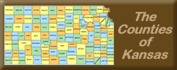
Kiowa County, in the southwestern part of the state, is the second county north from Oklahoma and the sixth east from Colorado. It is bounded on the north by Edwards county; on the east by Pratt and Barber; on the south by Comanche, and on the west by Ford and Clark. It was named for the Kiowa tribe of Indians and was first created by the act of 1867, which erected 26 western counties. In 1875 the county was extinguished and the territory divided between Edwards and Comanche. In 1886 Kiowa was restored and the boundaries defined as follows: "Commencing at the intersection of the west line of range 20 west with the north line of town 27; thence south along range line to its intersection with the north line of township 31; thence east along township line to where it intersects with the west line of range 15 west; thence north along range line to where it intersects with the north line of township 27; thence west to the place of beginning."
It contains 720 square miles or 460,800 acres. Until its organization Kiowa was attached to Comanche county for judicial purposes. Gov. Martin appointed C. W. Olmstead census taker in Feb., 1886. The returns made by him on March 19 showed a population of 2,704, of whom 549 were householders, and there was $236,622 worth of taxable property exclusive of railroads. In making the proclamation of organization on March 23, the governor named Greensburg as the county seat and appointed the following officers: Clerk, M. A. Nelson; commissioners, H. H. Patten, Jacob Dawson and C. P. Fullington.
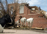
During the year 1886 three railroads made propositions to the people of the county—the Atchison, Topeka & Santa Fe, the St. Louis & San Francisco and the Chicago, Rock Island & Pacific. The proposition to issue bonds for the first was not carried, and that company changed its route. The Chicago, Rock Island & Pacific subsequently built a line from Hutchinson which came through this county, and later the Atchison, Topeka & Santa Fe built a line across the southeast corner. Greensburg, the county seat, was not founded until early in 1885. In less than 6 months it had 1,000 inhabitants and a number of two-story brick and stone buildings. About May 1, 1887, the ground for a court-house was purchased in Greensburg and the present court-house occupies the site.
The county is divided into twelve townships, Brenham, Butler, Center, Garfield, Glick, Kiowa, Lincoln, Martin, Reeder, Union, Ursula, Valley and Wellsford. The postoffices are, Greensburg, Belvidere, Haviland, Mullinville and Wellsford.
The surface of Kiowa county is a rolling prairie, slightly higher in the center. The southern half lies in the valley of the Medicine Lodge river and the northern half slopes in a succession of gentle foot hills toward the valley of the Arkansas. Rattlesnake creek, the principal stream, enters in the west and flows northeast into Edwards county. It has several tributaries in the northern and central parts. Medicine Lodge river has its source in the south and flows southeast into Barber county. Well water is found at an average depth of 50 feet. Good building stone is abundant.
Kiowa is in the famous winter wheat section. The wheat crop of 1910 sold for $1,674,553; corn, the next in importance, was worth $447,464; milo maize, $120,000; and animals sold for slaughter, $300,000. The total value of farm products was $2,740,959. The assessed valuation of property was $15,484,314. The population was 6,174 in 1910 as against 2,267 in 1900, a gain of nearly 300 per cent. The average wealth per capita is $2,346, which is larger by over $700 than the average for the state.
Law and government
Although the Kansas Constitution was amended in 1986 to allow the sale of alcoholic liquor by the individual drink with the approval of voters, Kiowa County has remained a prohibition, or "dry", county.
Geography
According to the U.S. Census Bureau, the county has a total area of 1,872 km² (723 mi²). 1,871 km² (722 mi²) of it is land and 1 km² (0 mi²) of it (0.03%) is water.
Demographics
As of the census² of 2000, there were 3,278 people, 1,365 households, and 924 families residing in the county. The population density was 2/km² (4/mi²). There were 1,643 housing units at an average density of 1/km² (2/mi²). The racial makeup of the county was 97.19% White, 0.21% Black or African American, 0.61% Native American, 0.27% Asian, 0.98% from other races, and 0.73% from two or more races. 2.04% of the population were Hispanic or Latino of any race.
There were 1,365 households out of which 27.70% had children under the age of 18 living with them, 59.60% were married couples living together, 5.30% had a female householder with no husband present, and 32.30% were non-families. 30.50% of all households were made up of individuals and 15.50% had someone living alone who was 65 years of age or older. The average household size was 2.32 and the average family size was 2.89.
In the county the population was spread out with 24.00% under the age of 18, 8.20% from 18 to 24, 21.80% from 25 to 44, 24.60% from 45 to 64, and 21.30% who were 65 years of age or older. The median age was 42 years. For every 100 females there were 96.30 males. For every 100 females age 18 and over, there were 95.10 males.
The median income for a household in the county was $31,576, and the median income for a family was $40,950. Males had a median income of $29,063 versus $20,764 for females. The per capita income for the county was $17,207. About 7.40% of families and 10.80% of the population were below the poverty line, including 13.50% of those under age 18 and 8.70% of those age 65 or over.
Cities and towns
Incorporated cities
Name and population (2004 estimate):
Greensburg, 1,452 (county seat)
Haviland, 589
Mullinville, 266
Unincorporated towns
Belvidere
Wellsford
Education
Unified school districts
Greensburg USD 422 (Closed for the 2006-07 school year. Will reopen for the 2007-2008 year)
Mullinville USD 424
Haviland USD 474