Comanche County was organized February 27, 1885. The county seat is Coldwater. The county was named from the Indian tribe of the same name. The county was first organized in 1873, under a general law then in force, and was represented in the Legislature under that organization in 1874, but that organization was held fraudulent and void. Lake Coldwater is a few miles Southwest of Coldwater.
An Early History of Comanche County
Frank W. Blackmar (1912)
Comanche County, one of the southern tier, is the sixth county east of the Colorado state line. It was created by an act of the state legislature in 1867, which provided for the division into counties of all the unorganized part of the state east of range line 26 west, and was named for the Comanche tribe of Indians. The act provided the following bounds for Comanche county: "Commencing where the east line of range 16 west, intersects the 6th standard parallel, thence south to the 37th degree north latitude, thence west to the east line of range 21, thence north to the 6th standard parallel, thence east to the place of beginning." By political divisions, it is bounded on the north by Kiowa county; east by Barber south by the State of Oklahoma, and west by Clark county. Its area is 795 square miles.
Before the county could be organized it was required by an act of June 4, 1861, that a census be taken and that the county should show a population of "600 inhabitants, excluding Indians not taxed, and who are bona fide residents of the county and the United States."
Actual settlement was slow. The first real settlers entered land during the spring and summer of 1873, but only a few attempted farming. A number of "cow men" took possession soon after the land was ceded to the government by the Osage Indians, and ranged thousands of head of cattle over this and adjoining counties. Some of the stockmen organized a company which became well known as the Comanche Pool." Very few men took up land for agricultural purposes until the spring of 1884, when a rush for the most desirable land began. This influx of homesteaders, who broke and in many cases fenced their land, ended the career of the "cow men." By the close of 1885 practically all the good claims in the county had been taken up. A majority of these pioneers were men of small means, who came into the county to lay the foundations of their fortunes.
In 1884 G. W. Vickers of Harper, Kan., conceived the idea of laying out a town in the northern part of Comanche county, in company with Timothy Shields, J. P. Grove, Samuel Sisson, C. M. Cade and C. D. Bickford, all from Harper county. They preëmpted a section of land, had it platted off as a town site and named it after the town of Coldwater, Mich. Early the following year the county had the required number of inhabitants, who petitioned the governor for its organization, and on Feb. 27, 1885, it was organized with Owen Connaughton, George M. Morris and David T. Mclntire, commissioners and R. A. Crossman, clerk. Coldwater was designated as the county seat.
In 1887 a branch of the Atchison, Topeka & Santa Fe railroad was built across the northwest corner of the county, from northeast to southwest, through Coldwater. It turned the tide of emigration to Comanche county, and added materially to the population. This is the only line in the county and farmers in the southeastern portion have to drive a considerable distance to market produce and ship cattle.
When news reached Comanche county that part of the Indian Territory was to be thrown open to settlement in April, 1889, the same restless, adventurous spirit that brought many of the settlers there in 1884 impelled them to take their worldly possessions and move to the new land of promise. When, in the spring of 1892, the Cheyenne and Arapahoe country was thrown open the depopulation of the county continued. In 1888 the assessors' report showed a population of 5,636, while that of 1890 was only 2,498. Hard times came with the dry years from 1891 to 1897, when crops were either a complete or partial failure, and the retrogression of the county reached its climax in 1896, when the population fell to only 1,269.
During these years when the settlers were leaving, fields lay untilled, homes were abandoned and property values depreciated. The so-called "Cattle Barons" fenced in all the land within reach for pasture. They paid light taxes, owned little land and ranged large herds at will. The many streams afforded fine water for the stock, cattle brought a good price, and these may be called the palmy days of the second generation of the "cow men," some of whom held the land so long that they seemed to think they had an indisputable right to it.
By their influence and activity in local politics, they managed to secure the election to the principal county offices men who were friendly to their claims, and the homesteader who wished to locate in the county found everything against him. This domination of the cattle men lasted until late in the '90s, when gradually but surely, the farmers began to gain in numbers and influence, and resettlement by small landholders began in earnest in the spring of 1905. Men in adjacent counties who had not sufficient land, removed to Comanche, which is becoming one of the leading agricultural counties of southwestern Kansas, and ranks especially high in stock raising.
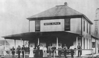
The pioneer papers of Comanche county were the Western Star, edited by W. M. Cash and W. T. Willis, and the Coldwater Review, owned and edited by Edward C. Austin. The first churches in the county were the Methodist and Presbyterian. George M. Norris and Dr. Lambart were the pioneer merchants. The county is divided into the following townships: Avilla, Coldwater, Irwin, Logan, Nescatunga, Powell, Protection, Rumsey, Shimer and Valley. Coidwater, the county seat, is the largest town and commercial center. It is a few miles northwest of the center of the county.
The general contour of the county is level except where the land breaks into bluffs along some of the larger streams. The valleys and second bottom lands are alluvial deposits and very fertile. The many streams are fringed with narrow belts of timber, chiefly cedar, walnut, elm and cottonwood. Sandstone, mineral paint and gypsum are plentiful, while salt springs are numerous in the southwestern portion. The Cimarron river flows southeast across the southwest corner of the county. Its principal tributaries in the county are Calvary creek, which flows south through the western part. The eastern portion is well drained by Mustang, Nescatonga, Indian and Big Mule creeks, all of which are tributary to the salt fork of the Arkansas river. A pamphlet issued by the state department of agriculture, entitled, "Kansas, Her Story and Statistics," stated that in 1907 there were 32 organized school districts in the county and a school population of 597. The population in 1910 was 3,281, a gain of 1,682 during the preceding ten years, or more than 100 per cent. The assessed value of property was $9,242,528, a per capita wealth of over $3,200, and the value of farm products for the year was $1,491,801.
Law and government
Although the Kansas Constitution was amended in 1986 to allow the sale of alcoholic liquor by the individual drink with the approval of voters, Comanche County has remained a prohibition, or "dry", county.
Geography
According to the U.S. Census Bureau, the county has a total area of 2,045 km² (790 mi²). 2,042 km² (788 mi²) of it is land and 4 km² (1 mi²) of it (0.18%) is water.
Demographics
Comanche County's population was estimated to be 1,935 in the year 2005, a decrease of 21, or -1.1%, over the previous five years. As of the U.S. Census in 2000, there were 1,967 people, 872 households, and 540 families residing in the county. The population density was 1/km² (2/mi²). There were 1,088 housing units at an average density of 1/km² (1/mi²). The racial makeup of the county was 97.97% White, 0.05% Black or African American, 0.25% Native American, 0.05% Asian, 0.20% Pacific Islander, 0.61% from other races, and 0.86% from two or more races. Hispanic or Latino of any race were 1.78% of the population.
There were 872 households out of which 24.40% had children under the age of 18 living with them, 54.40% were married couples living together, 6.20% had a female householder with no husband present, and 38.00% were non-families. 35.90% of all households were made up of individuals and 21.20% had someone living alone who was 65 years of age or older. The average household size was 2.18 and the average family size was 2.81.
In the county the population was spread out with 22.10% under the age of 18, 4.50% from 18 to 24, 21.00% from 25 to 44, 26.50% from 45 to 64, and 25.80% who were 65 years of age or older. The median age was 47 years. For every 100 females there were 93.60 males. For every 100 females age 18 and over, there were 87.50 males.
The median income for a household in the county was $29,415, and the median income for a family was $36,790. Males had a median income of $24,844 versus $18,221 for females. The per capita income for the county was $17,037. About 8.50% of families and 10.20% of the population were below the poverty line, including 9.70% of those under age 18 and 7.70% of those age 65 or over.
Cities and towns
Incorporated cities
Name and population (2004 estimate):
Coldwater, 763
Protection, 533
Wilmore, 56
Unincorporated places
Buttermilk
Education
Unified school districts
Comanche County USD 300
|