Early History of Chase County
by William G. Cutler (1883)
Location and Natural Features
Chase County, named after Salmon P. Chase, who was United States Senator from, and Governor of, Ohio, and Chief Justice of the Supreme Court of the United States, was organized in 1859. It was south and west of the center of population of Kansas in 1875, and in 1880 this center had moved some distance west of it. The northern boundary of the county is 102 miles south of the Nebraska line; its eastern line, 96 miles from the State of Missouri; its southern boundary, 75 miles from the Indian Territory; and its western boundary, 285 miles from the State of Colorado.
Between it and Missouri there are four counties; there are six organized counties on the line west of it. Its area is about 750 square miles. The Cottonwood River flows through the county in a general northeasterly and easterly direction, emptying into the Neosho, in Lyon County. The valley of this river ranges from one to three miles in width; its soil is chiefly a dark friable loam, varying from five to twenty-five feet deep, the accumulation of the decayed vegetation of ages. The river has high steep banks, and it has a fall of from five to eight feet in every half a dozen miles, thus making a series of good water-powers.
The limits of the river valley are most clearly defined by lines of bluffs or low and rounded sloping hills on either side, out of which crop ledges of magnesian limestone. The land is very rolling above the line of bluffs, and in many places it is broken by the ledges of stone that come out to the surface. Lying between the hills are swells of greater or less dimensions, that possess the elements of great fertility. The Cottonwood has numerous tributaries; the principal streams flowing into it from the north being French, Silver, Middle, Diamond, Fox, Peyton and Buckeye, the general course of which is southeast; from the south are Jacobs, Bloody, South Fork Rock, Spring, Corn Branch, Coon and Cedar, whose general course is north.
The head-waters of the Verdigris are in the southeastern part of the county; the stream runs southeasterly into Lyon and Greenwood and empties into the Neosho. In the northeast part of the county is Canola Creek; it passes through the southeast corner of Marion and empties into the Neosho, in the southwest corner of Lyon County. There are branches of all these tributaries fed by abounding springs of living water, and this network of running waters, great and small, give to this county the justly earned reputation of being one of the finest watered portions of the State of Kansas. These branches of the Cottonwood possess rich, fertile valleys, varying from half a mile to a mile in width.
The valleys are mostly on the west and north side of the streams; on the south and east the land usually rises abruptly to a summit, then gradually descends southwardly and eastwardly to the adjacent valley and stream. About 15 per cent of the county is valley land; 50 per cent, good tillable, undulating prairie, and 35 per cent of a bluffy character. Good well water can be obtained at a depth of about twenty-five feet. The streams are well skirted with timber, but the average width of the belt is less than one half a mile; the forest land of the county is estimated at 5 per cent. Cottonwood, hackberry, sycamore, hickory, walnut, and burr oak are the prevailing kinds of timber.
The soil is generally quite strongly impregnated with lime; the subsoil is of a clayish cast, but in the western part of the county, there is a smaller percentage of lime in the soil, and the subsoil is more porous. Building stone exists in great quantities, and it is of a most excellent quality. The west of the State house is built of it. It is seen in the public and private buildings at Leavenworth, Kansas City and in many of the principal towns along the Atchison, Topeka & Santa Fe Railroad and its branches. Good brick clay is found in the valley of the Cottonwood. The grasses growing from this soil are superior in their qualities for fattening stock, and the sheltered sides of the bluffs, the nooks at the head of the valleys, with the abounding timber, with artificial shelters, make this a peculiarly good county for raising and fattening of cattle.
There is comparatively no stagnant water in the county, nor swampy lands, and with the high altitude of the country, there is a great freedom from malaria. The winters are usually short, the spring opens early, and the autumn days are balmy, breathing an atmosphere of great purity with healing in its wings.
County Organization
Chase County was established by an act of the Territorial Legislature of 1859, which was approved by Governor Medary, February 11. Its territory was taken from the counties of Wise and Butler; the township line between Townships 17 and 18 was made the south boundary of Wise; that between Townships 21 and 22 the north boundary of Butler.
The Presidential vote of Chase County has been as follows: 1864, Lincoln, 79, McLellan, 47; 1868, Grand, 243, Seymour, 71; 1872, Grant, 481, Greeley, 187; 1876, Hayes, 594, Tilden, 214, Cooper, 40; 1880, Garfield, 716, Hancock, 324, Weaver, 409. In 1876 Green Clay Smith received 6 votes. On the Prohibition Amendment to the State Constitution, the vote cast in 1880, was 597 for; 660, against. In 1867, on the amendment to strike out the word "white" from the constitution, the vote was 120 for; 123 against. To strike out the word "male" the vote stood 118 for; 125 against.
Chase County was located in the Fifth Judicial District, and on November 5, 1861, R. M. Ruggles was elected Judge, receiving 376 majority over his opponent, W. R. Saunders, in a vote of 1,554. Ruggles had 3 majority in the county. In 1864 J. H. Watson had 235 majority over Ruggles in a vote of 1,781. Chase County had a tie vote on Judge. March 4, 1867, William R. Brown was elected Judge over Judge Wood, both being residents of Cottonwood Falls. Judge Brown was again chosen in 1872, having a majority of 302 votes in a vote of 676 cast in the county of Chase. He had 347 less votes than Frank Doster in Marion.
County Buildings
April 3, 1863, the county purchased of George W. Williams, a log-house and a lot for a court house for $175. It is situated northwest of the present court house, and its present existence in its primitive condition is an illustrative example of a county "living within its means." Terms of the District Court were held for a considerable time in the Congregational Church.
The voters of Chase County on May 23, 1871, gave 235 votes for public buildings; 107 against. Bonds to the amount of $40,000 were voted for public buildings on August 16, 1871, by a vote of 301 to 234. September 5, 1871, Isaac Alexander donated the west one-half of Block 28, and the east one-half of Block 29, comprising with the street between, about two and one-half acres for court house and jail purposes, whenever Cottonwood Falls was incorporated and could convey to the County of Chase. The Public Square was donated for school purposes. The town became a city of the third class in 1872. Its first Mayor was W. S. Smith; M. C. Newton, City Clerk; C. C. Whitson, Marshal; J. S. Doolittle, Police Judge; George W. Williams and A. S. Howard, were among its Councilmen.
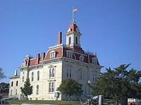
The court house bonds were sold October 1, 1871, at a discount of 12 per cent, and on October 28, a contract was entered into with James Bannan, of Leavenworth, to erect the structure for $36,945. It was finished November 13, 1873, and accepted by the County Commissioners at a cost of $42,599.88, certain additions having been made to it. The jail is on the south end of the building, and it is admirably fitted up for the convenience and safety of its prisoners, being furnished with the best of cells. The court house is one of the best in Kansas, it is built on the Renaissance style of architecture, of the period of Louis XIII. It is three stories high, with a basement and cupola. The jail is two stories high. John G. Haskell, of Lawrence, was the architect.
Schools and Other Statistics
There are four teachers employed in the new schoolhouse, completed in 1882, at a cost of $10,000. This school has a high reputation throughout the State. The pupils number nearly 300. This site is one of the most sightly places in the town; objects here can be seen twenty miles distant. In 1867, there were nine schoolhouses in Chase County; in 1870, 18; in 1878, 35; in 1882, 45, and 53 school rooms. The school population is 2,140. The visitations of schools by the Superintendent in 1882, was 73. There are 44 School Districts in the county; three of which are joint with Lyon, one with Morris, and one with Marion. The average school levy is 9.95 mills on the dollar; the schoolhouse bonds voted in 1882, were $12,850; the total amount of bonds is $16,130. There were 10 teachers of grade one; 42 of grade two; 12 of grade three. There was one Normal graduate.
In 1859, the population of the county was 549; in 1860, 1,046; in 1870, 1,989; in 1875, 3,116; in 1880, 6,081.
The valuation of church property in the county is estimated at $15,000. The organizations are classified as follows: Roman Catholic, United Presbyterians, and Universalists, each one; Baptist, Congregationalist, and Christians, each two; Methodists, fourteen; Quakers, one.
The county management of Chase has been on a very economical basis. Its early County Officers worked without pay, and acting upon the admonition: "Despise not the day of small things," the early settlers preferred to labor under inconveniences, rather than to place themselves under the burdensome taxation. The first tax levy was made November 11, 1859, and seven mills was levied for county, and three mills for school purposes. In 1859, the valuation of real estate was $43,725; of personal property, $25,811; total assessment, $71,536. In 1860, the assessment was as follows: real estate, $131,147; personal property, $43,137; town lots, $1,794.50; total, $176,078.40. In 1871, the assessment was $749,457; in 1882, it was $1,822,860.90, of which $289,460.90 was the assessment of the Atchison, Topeka & Santa Fe Railroad Company.
Chase County's average yield of winter wheat per acre in 1882, was 24 bushels. William Wood, near Cottonwood Falls, had 24 acres that yielded 44 bushels per acre. Little May and Fultz are the preferred varieties. The spring wheat average was 16 bushels to the acre; corn, 40; oats, 45; rye, 18; flax, 10. It has 3,648 horses and mules; 19,500 head of cattle; 7,697 sheep; 5,047 swine, which are mostly of the Berkshire and Poland-China breeds. Here are six months of good grazing; the cost per head for grazing cattle for the season is $1.25. Prairie hay in stack $2 per ton. There is no herd law in force, and 75 per cent of the county is open range.
Demographics
Chase County's population was estimated to be 3,070 in the year 2006, an increase of 37, or +1.2%, over the previous six years.
As of the U.S. Census in 2000, there were 3,030 people, 1,246 households, and 817 families residing in the county. The population density was 2/km² (4/mi²). There were 1,529 housing units at an average density of 1/km² (2/mi²). The racial makeup of the county was 96.90% White, 1.02% Black or African American, 0.56% Native American, 0.13% Asian, 0.56% from other races, and 0.83% from two or more races. Hispanic or Latino of any race were 1.75% of the population.
There were 1,246 households out of which 28.30% had children under the age of 18 living with them, 54.60% were married couples living together, 7.60% had a female householder with no husband present, and 34.40% were non-families. 31.10% of all households were made up of individuals and 14.90% had someone living alone who was 65 years of age or older. The average household size was 2.34 and the average family size was 2.92.
In the county the population was spread out with 24.10% under the age of 18, 6.50% from 18 to 24, 26.60% from 25 to 44, 24.10% from 45 to 64, and 18.70% who were 65 years of age or older. The median age was 40 years. For every 100 females there were 103.90 males. For every 100 females age 18 and over, there were 99.40 males.
The median income for a household in the county was $32,656, and the median income for a family was $39,848. Males had a median income of $27,402 versus $21,528 for females. The per capita income for the county was $17,422. About 4.10% of families and 8.60% of the population were below the poverty line, including 10.00% of those under age 18 and 6.30% of those age 65 or over.
Cities and towns
Incorporated cities
Name and population (2004 estimate):
Cottonwood Falls, 959 (county seat)
Strong City, 583
Matfield Green, 62
Cedar Point, 55
Elmdale, 51
Unincorporated places
Bazaar
Clements
Gladstone
Hymer
Matfield Green
Rural
Saffordville
Toledo
Wonsevu
Education
Unified school districts
Chase County USD 284