With the Indian Wars and the railroads both moving further and further west, Fort Harker was no longer needed as a military installation. It was officially ordered closed on April 8, 1872 and over the next several months was sold to developers. The new town was given the name of Kanopolis because it was envisioned as the "Central Metropolis" of the state and in due time was to be its capitol. It was laid out to provide for a city of 150,000 people by the Kanopolis Land Company.
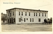
Kanopolis was incorporated January 6, 1887. "The Kanopolis Journal", a weekly newspaper of Kanopolis printed and distributed 50,000 sample copies that were sent back East to promote "The Future Great City" of central Kansas with an unequalled location and natural advantages. This issue dated May 24, 1890, told of two large hotels, a hardware store, roller mill, woolen mills, foundry and irons works, carriage works, an earthenware works, an elevator, the Union Pacific depot, three churches and a school.
Although Kanopolis did not reach the proportion that the early planners had hoped and worked for, the town has prospered through the years. Many of the early business places have disappeared and new ones have taken their places. It has a library and community center on the park grounds.
The Early History of Kanopolis
by Frank W. Blackmar (1912)
Kanapolis, formerly Fort Harker (q. v.), an incorporated city of the third class in Ellsworth county, is located on the Union Pacific R. R. 5 miles east of Ellsworth, the county seat. It has a bank, a grain elevator, a weekly newspaper (the Journal), telegraph and express offices, and a money order postoffice with two rural routes. The population, according to the census of 1910, was 577.
During its boom Kanapolis was one of the most extensive "paper" towns ever conceived. It was founded in May, 1886, and printing presses were kept busy night and day for a time by the promoters, getting out advertising for what they claimed was going to be a great city by 1900. Sky scrapers loomed up in their vision. The site was laid out on a scale suitable for a city of 150,000 people. Four blocks were reserved for a "State House Grounds;" lots sold as high as $1,000. An incident of the legislative war of 1893 was an attempt by the Populists to move the state capital from Topeka to Kanapolis.
Geography
Kanopolis is located at 38°42'35N, 98°9'25W (38.709707, -98.157020).
According to the United States Census Bureau, the city has a total area of 3.1 km² (1.2 mi²), all land.
Demographics
As of the census of 2000, there were 543 people, 248 households, and 153 families residing in the city. The population density was 174.7/km² (453.7/mi²). There were 295 housing units at an average density of 94.9/km² (246.5/mi²). The racial makeup of the city was 85.21% White, 0.37% African American, 0.18% Asian, 2.76% from other races, and 1.47% from two or more races. Hispanic or Latino of any race were 12.71% of the population.
There were 248 households out of which 25.4% had children under the age of 18 living with them, 49.2% were married couples living together, 9.3% had a female householder with no husband present, and 38.3% were non-families. 34.3% of all households were made up of individuals and 18.1% had someone living alone who was 65 years of age or older. The average household size was 2.19 and the average family size was 2.80.
In the city the population was spread out with 22.1% under the age of 18, 6.3% from 18 to 24, 23.8% from 25 to 44, 25.2% from 45 to 64, and 22.7% who were 65 years of age or older. The median age was 44 years. For every 100 females there were 96.0 males. For every 100 females age 18 and over, there were 90.5 males.
The median income for a household in the city was $31,413, and the median income for a family was $39,531. Males had a median income of $30,170 versus $21,250 for females. The per capita income for the city was $16,161. About 4.6% of families and 6.9% of the population were below the poverty line, including 1.7% of those under age 18 and 12.8% of those age 65 or over.