The City of Horton operates its own local distributing company (LDC), having a 5 megawatt generating facility; a water treatment and distribution system, treating, on average, 180,000 gallons per day; and a water pollution control center, which treats nearly 160,000 gallons of wastewater per day. Additionally, the City constructs and maintains over 25-miles of street infrastructure and provides 24-hour a day 911 and police service.
Early History of Horton
by Frank W. Blackmar (1912)
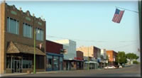
Horton, the largest town in Brown county, is an incorporated city of the second class, located on the Chicago, Rock Island & Pacific R. R. 14 miles south of Hiawatha, the county seat. It has electricity for power and lighting purposes, waterworks, fire department, opera house, 3 banks, 2 weekly newspapers (the Headlight and the Commercial), good hotels and about 250 business establishments. The Rock Island shops are located here. The town is supplied with telegraph and express offices and has an international money order postoffice with three rural routes. The population according to the census of 1910 was 3,600.
Horton is one of the newer towns in this part of the state. It was founded in Sept., 1886. A weekly paper was started the next month. In Sept., 1887, the Chicago, Rock Island & Pacific shops, the largest owned by that road in the west, were completed, and Horton had grown large enough to be incorporated as a city of the second class. The next month a daily paper was established. A fire department was organized in November of the same year. In May, 1888, the street railway line was completed and put into operation. In July the electric light plant began business, and when the city was two years old it claimed a population of 4,600. The main cause of the rapid growth was the railroad shops, which were built to employ 2,500 men. The waterworks went into operation in 1889. In 1891 there was a disastrous fire which destroyed the best business blocks in town, the loss aggregating $120,000.
Geography
Horton is located at 39°39'50N, 95°31'41W (39.663817, -95.528130). According to the United States Census Bureau, the city has a total area of 4.6 km² (1.8 mi²). 4.5 km² (1.8 mi²) of it is land and 0.57% is water.
Demographics
As of the census of 2000, there were 1,967 people, 812 households, and 506 families residing in the city. The population density was 434.0/km² (1,125.8/mi²). There were 906 housing units at an average density of 199.9/km² (518.5/mi²). The racial makeup of the city was 84.65% White, 0.97% African American, 10.78% Native American, 0.66% Asian, 0.51% from other races, and 2.44% from two or more races. Hispanic or Latino of any race were 2.08% of the population.
There were 812 households out of which 29.3% had children under the age of 18 living with them, 47.3% were married couples living together, 11.6% had a female householder with no husband present, and 37.6% were non-families. 34.5% of all households were made up of individuals and 18.8% had someone living alone who was 65 years of age or older. The average household size was 2.35 and the average family size was 3.00.
In the city the population was spread out with 27.5% under the age of 18, 6.7% from 18 to 24, 22.9% from 25 to 44, 20.2% from 45 to 64, and 22.7% who were 65 years of age or older. The median age was 39 years. For every 100 females there were 88.4 males. For every 100 females age 18 and over, there were 84.1 males.
The median income for a household in the city was $22,991, and the median income for a family was $31,447. Males had a median income of $25,000 versus $21,474 for females. The per capita income for the city was $13,063. About 14.0% of families and 17.4% of the population were below the poverty line, including 17.9% of those under age 18 and 18.5% of those age 65 or over.
|